
The Delaware Water Gap is bounded by Mt. Minsi in Pennsylvania and Mt. Tammany in New Jersey. Once touted as a scenic Wonder of the World, it is an impressive site when motoring through on Interstate 80 or viewed from the overlooks along Rt. 611 on the Pennsylvania side.
Before the Gap formed. Mt. Minsi and Mt. Tammany formed one continuous ridge -- the Kittatinny Ridge, along which the Appalachian Trail
Haney’s Mill in in the Delaware Water Gap National Recreation Area of New Jersey, and it offers beautiful view and an interesting geologically-themed hike that allows you to walk back 430 million years. (That should impress the kids.)
 |
| via http://www.geocaching.com |
If you look up and to the west, you’ll see the crest and western flank of Kittatinny Mountain. The rocks you see on Kittatinny Mountain are older than the limestones in the outcrop there.
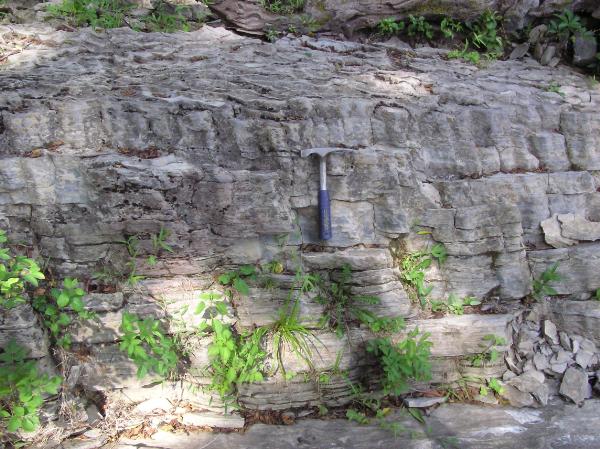
The gray, white and red rocks on Kittatinny Mountain, called sandstones and shales, formed from sediments that were deposited in rivers and shallow marine environments. The light gray rocks where you will be hiking are limestones, formed under different conditions, in the quieter waters of lagoons and intertidal zones.
The gray sandstones are middle Silurian in age, approximately 430 million years old. They formed from quartz-rich sediments left behind by fast-moving rivers that once flowed through the Taconic Mountains. The Taconic Mountains were part of a mountain range that once existed to the east and north of this site, but have since eroded away.
Over several million years, conditions changed, and the environment became more tranquil. Slow-moving rivers carried less sand and clay to the coast, and the coastal waters became clear. Slowly the type of sediment that formed in the marine waters changed from river-supplied sand and clay to limestone formed by marine animals.
THE TRAIL: A footpath, located across Capner Street, can be accessed through the paved parking lot on the north side of the park. The entrance to the footpath is just before the electrical transfer station adjacent to the Morales Nature Preserve. Once on the footpath, proceed north approximately 50 yards, until you see a path to the right angling down toward the brook. The exposures run north-south along the brook.
You can park in the small dirt lot just south of the bridge over Flat Brook.
This is a popular fly-fishing spot too.

Information for Teachers and Lifelong Learners:
http://www.nps.gov/dewa/forteachers/curriculummaterials.htm
http://www.njgeology.org/
DELAWARE WATER GAP (Images of America)
When Dinosaurs Roamed New Jersey
No comments:
Post a Comment