Showing posts with label day trips. Show all posts

Friday, July 25, 2025

Hiking Through New Jersey 200 Years Ago


If you are up for a weekend to hit the trails, maybe you will want to see New Jersey as it was 200 years ago. 

Okay, this is not a time travel story. The New Jersey stretch of the Appalachian Trail (AT) starts in the northern-most corner of the state at High Point State Park at Route 23 and extends down to the Delaware Water Gap. This is another one of those areas of NJ that will surprise even natives - you will forget that you are in NJ, or you will realize (as with our beaches) that we compete very well with other states that are more known for their outdoor recreation and scenery. 
Some sections of the AT look very much as they did 200 years ago. That was not colonial days, and NJ had become more industrialized and cities were growing, but this part of the state was still mostly undeveloped.

Most of us will never be the full AT. "Through-hikers" that do the 2000-mile Appalachian Trail across the tops of the Appalachian Mountains from Georgia to Maine are a unique breed of hiker. More people hike the trail in sections, and the 72 miles of it through New Jersey can be further divided into some great one-day hikes.

The NJ AT is intersected by country lanes or Park roads about every 5 to 10 miles, which makes it easier to do the trail in stages. The trail is well-maintained by volunteers.


Pochuck Boardwalk, AT in Glenwood

If you are doing a section of 6 or more miles, you should have decent hiking boots (thick soles and high enough to give ankle support) that allow for some heavy socks and swollen feet. Dress for the weather and the bugs of the season (bring some spray). A light pack (the kids' school backpack can do for a day), lunch, and some trail snacks (trail mix is not required!),  and a good supply of water. A fully charged cell phone is a must these days.

The New Jersey stretch of the Appalachian Trail is 74 miles long and begins at Abram S. Hewitt State Forest in the northernmost point, running west and south through Wawayanda State Park, High Point State Park, Stokes State Forest, and ending at Worthington State Forest.


Wawayanda Mountain to Warwick Turnpike (6 miles) is a good one-day hike. Wawayanda State Park extends across 13,000 acres of wild land. It is a remote plateau covered by rhododendron bogs where bears forage, craggy cliffs where coyote and bobcat make their dens, and hemlock ravines through which fast-moving streams surge and plummet. 

This mountain boasts some of the oldest bedrock along the entire AT. Go back 200 years? This area has a history of habitation that stretches back 12,000 years.

Sunrise Mountain and High Point at 17 miles is a more challenging one-day hike. (There are camping opportunities on sections of the trails.) The northern Kittatinny Ridge rises in an uninterrupted rampart, climbing to 1803 feet at High Point, the greatest elevation above sea level in New Jersey. This rugged AT ridge walk is punctuated by craggy ledges, far-reaching vistas. There are also manmade features, such as the Normanook Fire Tower, Sunrise Mountain Pavilion, and High Point Monument.

SOME SITES FOR INFORMATION & MAPS

http://www.AppalachianTrail.org

http://www.trails.com/activity.aspx?area=10129

http://www.njskylands.com/odhikeaptrl.htm

http://www.appalachiantrail.org
 and New Jersey focus from the Appalachian Trail Conservancy

Thursday, July 24, 2025

Greenbrook Sanctuary

Greenbrook Sanctuary is a 165-acre nature preserve located in Tenafly, New Jersey, within the Palisades region of Bergen County. It's about 4.7 miles north of the George Washington Bridge, off Route 9 West. This sanctuary is a unique blend of natural beauty and tranquility, offering a serene escape from the urban sprawl of nearby New York City

In the wildest, most secluded acres, trees rise 100 to 130 feet and are often over 200 years old. Hikers and walkers here feel hundreds of miles and years away from the cities in such primeval forests.

The sanctuary boasts a range of ecosystems, including mixed oak forests, cliff edges, ponds, ravines, meadows, and wetland forests. These support a wide variety of plant and animal life, such as over 250 species of birds and numerous small mammals.

It has a network of  6.5 miles of trails suitable for all levels of hikers, offering stunning views of the Hudson River and the surrounding landscape.

The sanctuary is home to a diverse range of wildlife, including deer, foxes, and birds of prey like bald eagles and peregrine falcons.

If you pay attention to geological features, the area features rocky cliffs, wooded areas, and a shoreline along the Hudson River, providing scenic views and unique habitats.

A five-acre pond with a small adjoining bog increases the great diversity of this sanctuary. The 250-foot Greenbrook Falls is one of three major streams that drain the area and tumble down the ancient diabase cliffs into the Hudson River. Views of these waterfalls, the Palisades and Highlands to the north, and the densely populated cities across the Hudson, are possible from several promontories which look down 350 feet into the river.

During the migratory seasons, it is not unusual to observe eighty species in one day, including twenty varieties of colorful warblers and, in the fall, thousands of hawks (and an occasional eagle) soaring along the cliffs. Nesting birds are the great horned owl, broad-winged hawk, pileated woodpecker, ruffed grouse, wood duck, scarlet tanager, rose-breasted grosbeak, worm-eating warbler, and indigo bunting.

Common mammals include the nocturnal raccoon, red fox, striped skunk, gray squirrels, chipmunk, muskrat, cotton-tail rabbit, and the secretive white-footed mouse, short-tailed shrew, and common mole. Deer, opossums, weasels, flying squirrels, and red bats are also occasionally seen.

One caveat is that access to hiking Greenbrook Sanctuary requires a membership. Palisades Nature Association, (PNA) is a non-profit organization of conservation-minded people, founded in 1946 to preserve the natural character of the Palisades cliffs and to develop a wild sanctuary. PNA administers Greenbrook Sanctuary and members are required to follow the rules and regulations to support their conservation efforts, ensure the safety of fellow members, and preserve the wildlife and natural environment of Greenbrook Sanctuary.

More Information at njpalisades.org and greenbrooksanctuary.org/


Tuesday, July 22, 2025

Walking The Path A Little At A Time

Crossposted from Weekends in Paradelle, where I had written about how "Less Is More" thinking had led me to rethink my Appalachian Trail hiking plans.


The "true" Appalachian Trail (AT) hikers are known as "thru-hikers." Those are people who hike the trail from end to end, all at once. That was my original plan and inspiration. You read the books about those experiences and see that they are life-changing experiences, and you feel inspired.

You also realize that it will cost thousands of dollars in supplies and take about five months (on average) away from family and work to accomplish. Of course, you don't just start walking. You need to be a seasoned hiker, in excellent condition, and with a wealth of outdoors knowledge.

Realizing that being a thru-hiker was not meant to be for me, I decided on a simpler path. There are several ways to do that.

Day hikers spend an afternoon covering about 2-6 miles. Weekend hikers have their backpacks with several days of provisions. Both approaches are a good way to train and to evaluate whether or not you're ready for a more challenging adventure.

Taking it up a few notches brings you to the section hikers. These hikers will take to the wilderness for weeks. They will take on a portion of the trail piece by piece. This occurs with not only the AT but many other long trails that are done in stages over many years.

It's still my hope to do section hikes, even if I never connect all of them into a completed AT hike.

Most books will tell you that the most important factor is your physical condition. So, I may have to have the long-postponed knee surgery before I get too ambitious. I have done 20-mile hikes, but experienced hikers always say that it's those 50+ mile hikes that will open your eyes to what it's all about mentally and physically.

There are many books on all this, including guides to individual states and areas like the Appalachian Trail Guide to New York - New Jersey

I bought a number of the guides, but I would also recommend some of these titles for "armchair hikers" who want to experience the thru-hike via someone else's experiences.
More Online
http://www.bucktrack.com/Thru-hiking_the_Appalachian_Trail.html
http://www.whiteblaze.net

Friday, October 20, 2023

Fall Foliage in New Jersey

Fall colors at Apshawa Preserve, Passaic County

Are the trees in fall color yet in your area Not sure when to see peak color in your area? Check out a cool U.S. foliage prediction map at https://smokymountains.com/fall-foliage-map/. 

Want to take a drive this weekend to see some autumn color?  Here are some spot provided by New Jersey Conservation Foundation.

High Point – What could be better than standing atop New Jersey’s highest elevation, at 1,803 feet? High Point State Park in Sussex County is rugged, rocky and spectacular.


Sunrise Mountain – Located in Stokes State Forest in Sussex County, Sunrise Mountain offers panoramic views and a pavilion at the summit. You can hike there along the New Jersey portion of the Appalachian Trail, or drive to a parking lot near the overlook.


Palisades Interstate Park – Located along the Hudson River in New Jersey and New York, this park features dramatic cliffs rising from the river. There are amazing views from both the upper and lower sections of the park, and trails ranging from easy to strenuous.


Jenny Jump – Located in western Warren County, the ridge at Jenny Jump State Forest offers beautiful vistas of the Delaware Water Gap to the west and rural farm landscapes to the east.


Apshawa Preserve – This Passaic County gem offers rugged terrain and rocky outcrops, with trails leading down to the scenic Butler Reservoir in the center of the preserve.


Wildcat Ridge – If you want to see migrating hawks as well as fall colors, it’s hard to top the Wildcat Ridge Wildlife Management Area in Morris County. Hike a mile up to the Hawk Watch area and enjoy a bird’s eye view southeast toward Manhattan.


Eagle Rock Reservation – Owned by Essex County, this park along the ridge of the Watchung Mountains offers clear views of the New York skyline and lots of hiking trails.


Washington Rock State Park – This park in Somerset County offers history as well as a sweeping view of Central Jersey. The strategic location of the natural rock outcropping made it a valuable lookout during the American Revolution, allowing General George Washington to spy on British troop movements.


Delaware & Raritan Canal – For a fun hike on level terrain, the path at D&R Canal State Park in Hunterdon County is a great destination. Start in historic Stockton and head either north or south to see the bright foliage along the Delaware River.


Baldpate Mountain – The highest peak in Mercer County can be found at the Ted Stiles Preserve at Baldpate Mountain, named for the late conservationist who played a pivotal role in preserving it. The preserve includes trails and a historic mansion with a stone patio overlooking the Delaware River.


Cheesequake State Park – At the gateway to the Jersey Shore in Middlesex County, you can enjoy a pleasant hike over rolling hills and along boardwalks crossing marshlands.


Wharton State Forest – The Mullica River trail in Wharton State Forest in Burlington County has great views of wetland habitats along the Mullica River that put on a colorful show.


Belleplain State Forest – Covering 21,254 acres in Cape May and Cumberland counties, Belleplain is at the edge of the Pine Barrens, with a diversity of trees and shrubs. For pretty colors and water views, try the trails around Lake Nummy.


Cape May Point – With its shrub- and vine-covered dunes, Cape May Point State Park in the fall has a subtle beauty. The park offers a .5-mile wheelchair-accessible trail great for viewing fall colors and wildlife. For a more strenuous challenge, climb the 199 steps to the top of the lighthouse for a panorama of ocean, bay and dunes.


Sunday, October 11, 2015

New Jersey's Watchung Mountains

looking west
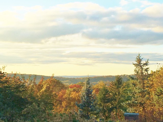
Looking west to Second Mountain from a ridge of First Mountain - part of the Watchung Mountains in New Jersey

Though New Jersey has many places that are called "mountains," we know that they do not compete with the western U.S. mountain ranges. Probably the best known NJ mountain area is the northwestern area where we find the Appalachian Trail.

But New Jersey also has the Watchung Mountains (once called the Blue Hills) which are actually a group of three long low ridges of volcanic origin, between 400 ft. (122 m) and 500 ft. (152 m) high, lying parallel to each other primarily in northeastern New Jersey.

All of the ridges lie to the east of the higher Appalachian Mountains, which in northern New Jersey are often referred to as the New York-New Jersey Highlands.

Together with the Appalachian Mountains to the west, the Watchungs pen in an area formerly occupied by the prehistoric Glacial Lake Passaic.

The Great Swamp, a large portion of which is designated as the Great Swamp National Wildlife Refuge, is a remnant of this lake. The swamp area is presently retained by what we call the Third Watchung Mountain.

200 million years ago, magma intruded into the Newark Basin, then an active rift basin associated with the breakup of the supercontinent Pangaea. The magma formed large intrusions like the Palisades Sill. But the magma ultimately broke out to the surface through large, episodic eruptions and formed the Watchung Mountains.


Throughout the early Jurassic period, the Newark Basin underwent extensive dipping and folding, and at the western edge of the Newark basin along the Ramapo Fault System formed alternating synclines and anticlines warped the layers of basalt and sedimentary rock. Jurassic sedimentary rock layers between and above the ridges form the Feltville, Towaco and Boonton formations.

The Watchung Mountains are known for their numerous scenic vistas overlooking the New York City and New Jersey skylines, as well as their isolated ecosystems containing rare plants, endangered wildlife, rich minerals, and globally imperiled traprock glade communities.

If you drive on I-280 up or down the big hill in "The Oranges", you see the cliffs that consist of a single massive lava flow that cooled and cracked into columnar joints.

In some locations, the joints tend to radiate away from a central core in a pattern generated by an uneven cooling pattern in the flow. There are also complex areas in the middle of the outcrop that show a small normal fault that may have formed from seismic activity that occurred about the time that the flows were still cooling. There are also lots of boulders (glacial erratics) scattered in the woods along the hilltop.

The ridges once held back the westward spread of urbanization, forming a significant geologic barrier beyond the Piedmont west of the Hudson River. But in many places within the state, they are smaller islands of natural landscape within suburban sprawl.

Parks, preserves, and numerous historical sites dot the valleys and slopes of the mountains, providing recreational and cultural activities to one of the most densely populated regions of the nation.

From near the summit of High Mountain in Wayne - in the right foreground is the eastern slope of Mount Cecchino
 (third highest peak of the Watchung Mountains)
Garret Mountain in the background (First Watchung Mountain) overlooking Paterson.

The two most prominent ridges are known as First Watchung Mountain (the southeastern ridge) and Second Watchung Mountain (the northwestern ridge). They stretch for over forty miles (64 km) from Somerville (in Somerset County) in the southwest through Morris County, Union County, Essex County, and Passaic County to Mahwah (in Bergen County) in the northeast.

The less prominent and discontinuous ridge formed by Long Hill, Riker Hill, Hook Mountain, and Packanack Mountain is sometimes referred to as Third Watchung Mountain and lies on the northwestern side of Second Watchung Mountain.

The First and Second Mountains are often erroneously referred to as Orange Mountain and Preakness Mountain. "Orange" and "Preakness" more properly applies to specific geographic sections of these ridges.

Third Watchung Mountain is sometimes referred to locally as Hook Mountain.

A smaller fourth ridge exists south of Morristown and west of Third Watchung Mountain. This ridge lacks topographic prominence, only rising to about 100 ft (30 m) above the surrounding terrain and the only named portion (at Harding Township) is known as Lees Hill.

The original inhabitants of the Watchungs were the Native American Lenape. They referred to the mountains as the Wach Unks, or ‘high hills’. Evidence of the Lenape presence in the Watchungs can be seen in numerous camps sites that have been uncovered, mainly along the rivers coursing through mountains and in the small caves abundant in the volcanic rock.

It is thought the Lenape favored the Watchungs for their profusion of natural resources, including abundant freshwater rivers and streams, a variety of forests, and plentiful fish and game. They also took advantage of the rich soils and maintained many farm areas where they raised a variety of seasonal crops.

With the arrival of Europeans, the rivers and streams of the Watchungs also supported grain, grist, and saw mills. Later, the energy of these rivers would be harnessed for industry, most notably at the Great Falls of the Passaic River, where mechanical and hydroelectric systems exploited the energy of water falling over the face of First Watchung Mountain.

During the Revolutionary War, General George Washington used the protection of the Watchung mountains to erect the first and second Middlebrook encampment. This position on the high ground also allowed him to monitor the area between Perth Amboy and New Brunswick as well as to identify and disturb British movements between Manhattan and Philadelphia.

During World War Two, an anti-aircraft gun emplacement was made in Mills Reservation (Cedar Grove & Montclair) at the lookout point on the cliffs overlooking New York City. All that remains of this today is a circular cement platform.

In the twentieth century, the Hilltop in Verona, the highest point in Essex County, served as the site of a sanatorium for tuberculosis patients. The county hospital was built there because the high elevation provided clean, mountain air away from the cities to the east.

At the height of the Cold War, Campgaw Mountain was selected to house a Nike missile base. Installed on the mountain between 1955 and 1971, the base’s missiles served to guard New York City air space, standing by to intercept nuclear armed Soviet bombers. The facility ultimately was abandoned with the advent of intercontinental ballistic missiles. Two other missile sites were nestled into the forests atop peaks in Mountainside and Morris Township, creating a triangle of redundant sites.

NYC skyline seen from Mills Reservation, First Watchung Mountain

There are many parks and recreational areas to visit along the Watchung Mountains.

Campgaw Mountain Reservation (First and Second Watchung Mountain) is the northernmost ridge of the Watchungs and its northern terminus is the Ramapo Mountains, near the New York border. A shallow gap separates its southern end from Preakness Mountain and Goffle Hill.

Preakness Mountain comprises part of the northern extent of Second Watchung Mountain between the Passaic River and Campgaw Mountain.[ Along with Packanack Mountain (part of Third Watchung Mountain) to the west, Preakness Mountain forms the Preakness Range. The three highest peaks of the Watchungs are located in this range.

Great Falls State Park in Paterson is on First Watchung Mountain.

Nearby Garret Mountain Reservation is 568 acre park located within the Borough of Woodland Park (formerly West Paterson), although it also extends into the cities of Paterson and Clifton. The reservation covers the northernmost part of the First Watchung Mountain and reaches over 500 feet (152 m) above sea level.

Continuing along the Watchung Mountains, popular locations include:
* Mills Reservation, First Watchung Mountain
* Hilltop Reservation, Second Watchung Mountain
* Eagle Rock Reservation, First Watchung Mountain
* Riker Hill Park, Riker Hill (Third Watchung Mountain)
* South Mountain Reservation, First and Second Watchung Mountain
* Watchung Reservation, First and Second Watchung Mountain
* Washington Rock State Park, First Watchung Mountain
* Washington Valley Park, First Watchung Mountain
* Leonard J. Buck Garden/Moggy Hollow Natural Area, Second Watchung Mountain

Wednesday, March 30, 2011

New Jersey Wineries

Renault Winery, Egg Harbor City   renaultwinery.com

New Jersey has a growing wine industry with more than 40 wineries producing over 225 different varieties of wines from dry and semi-dry to sparkling and fruit and dessert wines.

Most people think of taking winery tours in the autumn, but there are New Jersey wine festivals, special events, wine-tastings and new wine releases all year.

The Garden State Wine Growers Association as information on all of them.

For example, the “Blues & Wine Festival” is May 28 & 29, 2011 at Natirar Park in Peapack-Gladstone, NJ.

There's also a “Mother’s Day Wine Trail Weekend” on May 7 & 8, at participating wineries across the state.

For a list of NJ wineries and their websites, see http://www.state.nj.us/jerseyfresh/wine.htm

Saturday, March 19, 2011

Free Nature Walk Sunday, Laurel Hill


We posted about Laurel Hill (AKA Snake Hill) earlier this year.


Sunday, March 20, 10 a.m.
First Day of Spring Bird Walk 
with the NJMC and BCAS

This free two-hour nature walk starts at the ball fields of Laurel Hill County Park in Secaucus. We’ll look for the (possibly nesting) common ravens, raptors, waterfowl and herons on the Hackensack River, and any other birds we can find. We meet at the big parking lot by the Laurel Hill ball fields at 10 a.m. We will not also meet at the first parking lot in DeKorte Park in Lyndhurst at 9:20. The walk is run by the N.J. Meadowlands Commission and the Bergen County Audubon Society. Check meadowblog.net for last-minute weather updates. You will have to sign a standard liability release for this event. To rsvp, contact Don Torino of the BCAS at greatauk4@aol.com or 201-636-4022.

SOURCE: Free Nature Walk on Sunday, Laurel Hill from The Meadowlands Blog

Friday, March 11, 2011

Further Along on the Watchung Mountains

This post concludes our virtual walk along the parks and reservations of the Watchung Mountains.


We pick up the trail in Washington Rock State Park which is a 52-acre (210,000 m2) state park on top the first Watchung Mountain in Green Brook Township, New Jersey. The park is operated by the New Jersey Division of Parks and Forestry and is currently being managed by the Somerset County Park Commission. It is open daily sunrise to sunset.

It is famous for the scenic overlook which was used by General George Washington in 1777 to monitor British troop movements when the Continental Army was stationed at the Middlebrook encampment. The 30-mile (48 km) panoramic vista covers the eastern plains of New Jersey up to New York City, making it a valuable lookout point during the American Revolution. General Washington used it in June of 1777 when the British army under General William Howe was moving toward Westfield. From the vantage point of this natural rock outcropping, General Washington was able to instruct his troops to circle behind Howe’s troops and cut off their retreat.


One of the oldest state parks in New Jersey, Washington Rock was originally purchased in 1913 to commemorate the historical events of 1777. Situated on top of Watchung Mountain, the park is a popular site for easy walks, picnicking and relaxation.

Closely connected is Washington Valley Park. This 715-acre (2.89 km2) public park is between the first and second Watchung mountain ridge in the Martinsville section of Bridgewater Township. It is also administered by the Somerset County Park Commission.

This partially developed park has a western and eastern section separated by the Bound Brook Gap with the Chimney Rock Road that connects Bound Brook with Martinsville. The terrain is rocky and mountainous and covered with pine and hemlock.

At the center of the western section of the park is the 21-acre (85,000 m2) Washington Valley Reservoir. The reservoir was created in 1920 when the western branch of the Middle Brook was dammed. (Its former name was the Bound Brook/Elizabeth Reservoir.) The eastern section of the park has the much smaller East Branch Reservoir and the Buttermilk Falls of the eastern branch of the Middle Brook.

Adjacent to the park is the Chimney Rock Quarry built atop the old Chimney Rock Copper Mine (a.k.a. Bound Brook Quarry or Washington Mine).  There are still copper mines over 165 feet deep and active mining continues today. Copper from here was used to mold a small brass cannon later used at the siege of Yorktown during the Revolutionary War. There is also still calcite mined from the Chimney Rock Quarry and marble and granite taken from this area.

The reservoirs have no boat access but are of interest to anglers. Species that can be caught include largemouth bass, black crappie, bluegill, pumpkinseed, and yellow perch.

The park contains numerous trails that are used by hikers and mountain bikers.

At an outcropping of the first Watchung mountain ridge is Chimney Rock Hawk Watch. In the fall, the area is visited by birdwatchers to observe the annual southward migration of species including broad-winged hawks, sharp-shinned hawks, bald eagles and golden eagles. Hawk watching lasts from early September into November, the second half of September being the peak time.

The eastern part of the park was the site of a military fortification that was used by the Continental Army near the site of the 1777-78 Middlebrook encampment. Remnants can be found in the shape of earth walls. A look-out point is preserved that was used to observe movements of the British Army in the plains towards New Brunswick.

Two more areas to visit that are connected brings our walk to a close. The Leonard J. Buck Garden and the Moggy Hollow Natural Area are our last stops along the Second Watchung Mountain.

The Moggy Hollow Natural Area is a 14-acre (5.7 ha) nature preserve near Far Hills in Somerset County. It's an area of geologic interest. The area was designated a National Natural Landmark in January 1970.

As the Wisconsin Glacier advanced and ancient Glacial Lake Passaic formed, it deepened to 240 feet until it found an outlet to spill over at Moggy Hollow. From here the water drained to the Raritan river.

The ledge of harder basaltic rock at 331 feet (101 m) above sea level served as a spillway for Lake Passaic carving a deep ravine out of the softer soil as the lake drained. Moggy Hollow remained the main outlet as the glacier retreated due to natural debris dams until Little Falls and Paterson (Passaic County) emerged from the ice.

This 20-acre property adjacent to the North Branch of the Raritan River and the Far Hills Fairgrounds is a testament to the beauty of once-unchanged floodplains of the region. The floodplain is forested with a mixture of Oak, Maple, and some outstanding Sycamore trees. It is an excellent place to spot Kingfishers or Great Blue Heron. A trail runs parallel to the river and fishing is allowed in the trout-stocked waters.

The woodland and bog have ecological value, providing a diverse mixture of trees, shrubs and herbaceous plant species. But this is not an especially visitor-friendly site. The terrain is very steep and hazardous. Rocky slopes abruptly meet the bog, and walking is difficult, but worth the challenge for those who are interested in glacial geology.
The property is owned and managed by the Upper Raritan Watershed Association. Most of the current site was donated to the association in 1967 by J. Malcolm Belcher, a former mayor of Far Hills, on behalf of the Belcher family.


The ravine is located adjacent to and above the Leonard J. Buck Garden. Visitors can either ask to cross the Buck garden to reach the lower portion of the ravine, or park above on Liberty Corner Road to access the top of the ledge.

The garden is one of the premier rock gardens in the United States. It features native and exotic plants displayed in a naturalistic setting of woodland, streams, and rock outcroppings. A wooded, rocky ravine is home to numerous wildflowers interspersed among flowering trees and shrubs.

The best and most popular time to visit is in the spring.

The Garden began in the 1930s when geologist Leonard J. Buck, a trustee of the New York Botanical Garden, met landscape architect Zenon Schreiber and the two created varying exposures and microclimates.

The garden is sculpted from the glacial stream valley where waterfalls once cascaded, leaving behind rock faces, outcroppings, ponds and a stream. After Mr. Buck's death in 1974, the garden was donated by Mrs. Buck to the Somerset County Park Commission and was opened up to the public in 1977. A small donation is requested.

The plantings are extensive and include aconite, anemone, azalea, beech, birch, bloodroot, boxwood, Chinese fringe tree, columbine, cyclamen, daffodils, Dawn redwood, dogwoods, enkianthus, forget-me-nots, forsythia, geraniums, grape hyacinth, heathers, herbs, hornbeam, hydrangea, Japanese maple, Japanese painted fern, Japanese peonies, Labrador violets, magnolias, mahonia, maidenhair fern, maples, mountain laurel, narcissus, oak, ostrich ferns, primroses, rhododendron, saxifrage, shagbark hickory, Siberian squill, skimmia, snowbell, star magnolia, sweet woodruff, trillium, viburnum, violets, Virginia bluebells, and wind anemones. You can check their website to see what is in bloom during this season.

Friday, March 4, 2011

Princeton Battlefield Park

General Washington rallying his troops at the Battle of Princeton.
The first inhabitants of the Princeton area were the Lenni Lenape Indians. Europeans founded the settlement in the latter part of the 17th century. The first European to find his home in the boundaries of the future town was Henry Greenland who built his house in 1683 along with a tavern. It was in that tavern that representatives of West and East Jersey met to set boundaries for the location of the township.

Princeton was to be divided into two parts: a borough and township. It was founded from pieces of Middlesex, Burlington, Somerset and Hunterton counties which were divided by the central “King’s Highway.” The King's Highway is today's Nassau Street which eventually turns into Princeton-Kingston Road to the north and Stockton Street to the south.

Even though New Jersey's capital is the city of Trenton, the governor's official residence has been in Princeton since 1945. That is when Morven became the first Governor's mansion. It was later replaced by the larger Drumthwacket, a colonial mansion also located in the township. Morven is now a museum property of the New Jersey Historical Society.

Princeton Battlefield State Park is a 200-acre (81 ha) state park located in Princeton Township. The park preserves the site of the Battle of Princeton on January 3, 1777.

On the night before the battle, George Washington, Commander-in-Chief of the Continental Army, repulsed a British attack at the Battle of the Assunpink Creek in Trenton. That night, he evacuated his position, circled around General Lord Cornwallis' army, and went to attack the British garrison at Princeton. Brigadier General Hugh Mercer, of the Continental Army, clashed with two regiments under the command of Lieutenant Colonel Charles Mawhood of the British Army.

Mercer and his troops were overrun and Washington sent some militia under General John Cadwalader to help him. The militia, on seeing the flight of Mercer's men, also began to flee. Washington rode up with reinforcements and rallied the fleeing militia. He then led the attack on Mawhood's troops, driving them back. Mawhood gave the order to retreat and most of the troops tried to flee to Cornwallis in Trenton.

In Princeton itself, General John Sullivan forced some British troops who had taken refuge in Nassau Hall to surrender, ending the battle. After the battle, Washington moved his army to Morristown, and with their third defeat in 10 days, the British evacuated southern New Jersey. With the victory at Princeton, morale rose in the ranks and more men began to enlist in the army. The battle was the last major action of Washington's winter New Jersey campaign.

Princeton hosted the first Legislature under the State Constitution of New Jersey to decide the State’s seal, Governor and the organization of its government. In addition, two of the original signers of the Declaration of Independence—Richard Stockton and John Witherspoon lived in Princeton.

In 1783, Congress fled from Philadelphia to Princeton, fearing a mutiny by some of the soldiers. General Washington took up residency at Rockingham in Rocky Hill, where he wrote his Farewell Orders to the Army.

On September third, he rode to Nassau Hall to receive news that the Treaty of Paris had been signed, which officially recognized America's independence. Princeton, thereby, became the first Capital of the new nation.

The Battlefield Park is maintained by the New Jersey Division of Parks and Forestry, and is located on Mercer Road (Princeton Pike), about 1.5 miles south of Princeton University and 3.8 miles north of Interstate 295/95.

Besides the battlefield itself, another stop is the Mercer Oak named after Hugh Mercer, a brigadier general in the Continental Army during the American Revolution. During the Battle of Princeton, Mercer was stabbed by an English soldier's bayonet. According to legend, he was unwilling to abandon his troops, and rested on the tree's trunk while they stood their ground. After the battle, Mercer was taken to the Clarke House where he died from his injuries nine days later.

The tree was about 300 years old when it was torn by strong winds in March 2000. It is the emblem of Princeton Township and appears on the seal of the township and is an element of the seal of Mercer County, New Jersey. For public safety reasons, arborists cut off the remnants of the trunk the day after the tree fell and several scions from the tree were planted around the battlefield. In May 2000, an 8-foot sapling grown from a Mercer Oak acorn was planted inside the stump of the former tree.

The Thomas Clarke House Museum, built in 1772, was built by the third generation of Quakers at Stony Brook. The house is furnished in the Revolutionary period and contains military artifacts and battle exhibits, as well as a research library. During the battle General Mercer was brought to the Clarke House and treated unsuccessfully by Dr. Benjamin Rush.

There is also an Ionic Colonnade designed by Thomas U. Walter (architect of the US Capitol Building)and a stone patio marking the grave of 21 British and 15 American soldiers killed in the battle. A poem was written for the site by Alfred Noyes, Poet Laureate of England.

The park's hiking trails lead to the Delaware and Raritan Canal and to the adjacent property of the Institute for Advanced Study.

The Princeton Battle Monument is located near Princeton University on park property at Stockton Street and Bayard Lane.

The Historical Society of Princeton uses the Bainbridge House which had previously been used once for a meeting of Continental Congress in 1783, a general office and as the Princeton Public Library. The House is actually property of Princeton University and is leased to the Princeton Historical Society for one dollar per year. The house has kept its original staircase, flooring and paneled walls and is 70% unaltered.


Take a virtual tour of the Princeton Battlefield Park

Princeton Battlefield State Park official site

Friday, February 25, 2011

Delaware and Raritan Canal


Historic map of the D&R Canal
click image for large size via http://mapmaker.rutgers.edu
The Delaware and Raritan Canal (D&R Canal) is a canal in central New Jersey, that was built in the 1830s and served to connect the Delaware River to the Raritan River.

Delaware and Raritan Canal Company 24x36 Giclee
D&R Canal Company
It was intended as an efficient and reliable means of transportation of freight between Philadelphia, Pennsylvania and New York City, especially coal from the anthracite coal fields in eastern Pennsylvania. Before the advent of the railroads, the canal allowed shippers to cut many miles off the traditional route from the Pennsylvania coal fields. That route took the coal down the Delaware, into the Atlantic Ocean, around Cape May, and up along the coast to New York City.

Delaware and Raritan Canal at Work, The (NJ) (Images of America)The canal system was dug mostly by hand tools, mostly by Irish immigrants. Work began in 1830 and was completed in 1834, at an estimated cost of $2,830,000. When the canal first opened, teams of mules were used to tow canal boats through it (the steam engine was not yet applied to such uses).

The canal's greatest usage occurred during the 1860s and 1870s during the area's Industrial Revolution. On May 18, 1872, the D&R Canal Company was merged with several parallel railroads into the United New Jersey Railroad and Canal Company, and leased by the Pennsylvania Railroad. Over time, the importance of the D&R Canal waned as railroads were used to perform, more rapidly, the same function as canals, but it remained in operation until 1932.

Over the years, sections were filled for various road and rail projects and other sections of the canal were piped underground.

Today, the D&R Canal offers us a number of natural and historical resources, including 160 species of birds, wooden bridges, canal locks, historic bridge & canal houses, and former mill sites. The park can be enjoyed individually or at one of the many nature and history related programs that are offered throughout the year by the park's naturalist and historian.

The total length of the entire canal system was approximately 66 miles (106 km).

A steam tug docked on the canal in front of a Princeton hotel.

Unfortunately, some sections of the canal are forever lost. A section of the main D&R Canal in Trenton, along Mulberry Street, has been covered over (the water still flows below) and redeveloped, and is inaccessible to public use. The portion of the canal that provided access to the Delaware River in Bordentown is also abandoned. In Trenton it has been covered by NJ Route 129, which opened in 1996. Another section south of Trenton is located in Hamilton Township, Mercer County, New Jersey between the southern boundary of Trenton and the Crosswicks Creek.

Locks were used to overcome elevation differences along the D&R canal. Many of the locks are still present along the canal route; however, the lock gates have been replaced on the upstream side with small dams and water outfalls. The downstream gates have been removed, so the water in the locks is level with the water on the downstream side. Some of the locks have been buried or removed due to construction projects in the vicinity of the canal.

A number of spillways, which drained excess water from the canal into nearby waterways during periods of heavy flow, are located along the canal route. Spillways are evident as a dip in the tow path along the canal.


Image: bikinghikingwithkids.com

In 1974, most of the canal system was declared a New Jersey state park. It remains one today, and is used for canoeing, kayaking, and fishing.

A graded natural-surface trail along the side of the canal, which was the tow path that mules used to tow barges on the canal before steam powered barges, is now used for hiking, jogging, bicycling, and horseback riding. Some 36 miles (58 km) of the main canal, and all 22 miles (35 km) of the feeder canal, still exist. The feeder canal along the Delaware, being a former railroad rather than a towpath, is especially suited to bicycling. The park is operated and maintained by the New Jersey Division of Parks and Forestry.

The D&R Canal trail is a recreational trail of 77 miles (124 km) trail is made up of three segments that transverse three counties: a canal towpath from New Brunswick to Trenton; a canal towpath / rail trail from Trenton to Bull's Island; and a rail trail from Bull's Island to Frenchtown. The three combined trails together form the largest completed trail entirely in New Jersey. Much of the trail runs inside the state park. [Note: There is no direct connection between the main canal and the feeder canal paths along the Delaware River. Signed on-street connections are required to traverse the entire trail system.]

The proposed Capital to Coast Trail is planned to connect to the D&R Canal Trail.

The canal is accessible from many points along its route, with small parking areas providing access at most road crossings. One of the most scenic and popular sections of the D&R Canal state park is the segment along Lake Carnegie in Princeton, New Jersey, which features the canal on one side of the path and the lake on the other side. Another attractive section borders the Colonial Park Arboretum and Gardens in East Millstone.

The Delaware and Raritan Canal was added to the National Register of Historic Places in 1973 and the many historic canal houses where the bridgetenders lived (such as the Blackwells Mills Canal House and the Port Mercer Canal House) were listed as contributing properties.

Monday, February 21, 2011

Continuing Along The Watchung Mountains

This post continues our virtual walk along the Watchung Mountains that we began in an earlier post with three more stops in Essex in Union Counties.

Eagle Rock as seen on a 1907 postcard
Continuing south through New Jersey, we come to Eagle Rock Reservation, on First Watchung Mountain. The Reservation is a 408.33-acre (165.25 ha) forest reserve and recreational park primarily in the communities of West Orange, Montclair, and Verona. The land is owned and administered by the Essex County Department of Parks, Recreation and Cultural Affairs.

The reservation is named after the Eagle Rock, a bare rock looking down from the mountain, which marks the boundary between the towns of Montclair and West Orange, New Jersey. The Lenape Trail passes through the reservation.


Overlooking the Manhattan skyline is a memorial built in honor of those killed during the September 11, 2001 terrorist attacks with the names of all who perished at the World Trade Center or on the two planes that crashed into the twin towers permanently inscribed in a marble memorial.

That particular day, I left my job when the planes hit and drove home past this reservation where cars were lined along the road and at the overlook as people could clearly see the burning and then collapsing towers to the east.

Check out the Eagle Rock Reservation Conservancy for more information including a map.

Campbell's Pond - South Mountain Reservation
Our next natural area is South Mountain Reservation which covers 2,047.14 acres (8 km²) in central Essex County, New Jersey, in portions of Maplewood, Millburn and West Orange, bordering South Orange, between the first and second ridges of the Watchung Mountains.

Wikipedia gives us some history of the area. In 1896, John Durand described the mountain that includes South Mountain Reservation as:
“a wilderness, as it probably existed at the time of Hendrick Hudson, a primitive forest abounding with deer and other wild animals, and traversed by streams alive with trout. Game was plentiful – partridges, quail, woodcock, rabbits, squirrels of every species, raccoons and foxes; while occasionally a hungry bear that had trespassed on the farmyards in the vicinity would be tracked to its den and shot.”

In 1680, wolves, bears and cougars were observed in the area, and there was a bounty on them.

The park has a Revolutionary War historic site at what is called Washington Rock. It dates back to the late 18th century when Beacon Signal Station 9 was located here. It was one of 23 beacons built by General George Washington to observe British troop movements quartered on Staten Island and New York City.

From this outlook on June 23, 1780, Essex County and Newark Militia were first warned that the British had launched an attack westward toward "the Gap," (Hobart Gap), a natural pathway to Washington's troops encamped at Morris Town. In a pincer movement designed to gain access to the Gap, Hessian troops fought bitterly along Vaux Hall Road, while the British advanced along Galloping Hill Road, until they were repelled, the Hessians at the base of the mountain and the British in Millville (now Millburn).

Washington Rock served again as a lookout for the Army when reactivated during the War of 1812.

The reservation has been well preserved and is primarily in a wild state today. Woodlands abound in a variety of hardwood trees, and tall hemlocks tower above streams, creeks and ponds. The west branch of the Rahway River flows through the valley. A reservoir and watershed owned by the City of Orange lies in the northern tract.

As a youngster, I spent many days wandering this reservation. Our family often took weekend drives that included a stop along Crest Drive which leads to Washington Rock and once led to the "deer paddock" where we would feed the deer.

The paddock is gone (but the deer have certainly thrived) and Crest Drive has been closed to vehicular traffic at the point of the old paddock, but visitors can take an easy walk down to Washington Rock.

Though many people know the area from South Orange Avenue south to Millburn as the Reservation, it extends farther north and includes the Turtle Back Zoo and the South Mountain Arena. The zoo's train rides through the woods along the Orange reservoir.

From different locations, there are vistas allowing views of New York City, Elizabeth, Union Township, and even Staten Island.

Hemlock Falls is one dramatic feature, and neighboring Blackrock Falls is another picturesque smaller cascade. A hike to Hemlock Falls is a moderate one and uses the Lenape Trail.

The reservation was built from land purchases that started in 1895. Frederick Law Olmsted visited the newly acquired reservation and said it was some of the most beautiful and promising terrain he had ever seen. The Olmsted Brothers designed the park in stages with much of the construction work of trails, footbridges, and shelters being done by the Civilian Conservation Corps in the 1930s.

More at the South Mountain Conservancy 


Watchung Reservation is the largest park in Union County and it is bounded by the city of Summit, the borough of Mountainside, the townships of Berkeley Heights, Scotch Plains, and Springfield. The reservation consists mainly of the upper valley of Blue Brook, between the ridges of First Watchung Mountain and Second Watchung Mountain. A dam near the headwaters of the creek creates Lake Surprise.

The 1,945 acre (7.8 km²) parcel is forested, and the reservation is managed for the preservation of its natural resources, but it does contain playgrounds, golf courses, stables, and a museum within the reservation.

The most popular recreational activities in the reservation are hiking and horseback riding on its many trails. The county-owned Watchung Stables are located on a large cleared area in the eastern end of the park, and at the center is the Trailside area, a large park with picnic tables and playground equipment with the Trailside Nature and Science Center at the southern edge in Mountainside.

The land in the reservation is not as pristine and undeveloped as our earlier stops. In fact, an entire village, Feltville, once existed in the woods in the northwestern quadrant and recently became inhabited again.

One popular hike through the western reservation goes through a pine plantation planted by the Civilian Conservation Corps during the 1930s.

In the late 1950s, the U.S. Army built a Nike missile base here and operated it between 1957 and 1963 to defend the airways over New York City. It is now the site of the stables.

During the 1980s, NJDOT completed a section of Interstate 78 through the northern fringe of the reservation. An attempt was made to build "land bridges" to allow wildlife to travel safely between the split parts of the Reservation, but they failed to be successful.

A Reservation Map (pdf) is available along with more information at the Trailside Nature and Science Center.

Monday, February 14, 2011

Wild New Jersey: Nature Adventures in the Garden State


David Wheeler's book, Wild New Jersey: Nature Adventures in the Garden State has just been published by Rutgers University Press.

Wild New Jersey: Nature Adventures in the Garden State [Paperback]David is the Director of Operations for the Edison Wetlands Association and the founder of the Wild New Jersey blog which (like this blog) looks at environmental and wildlife news from around the state and often features videos.

The book is a through-the-year sweep of New Jersey from the mountains to the beaches. It's a reminder of how diverse our state is in its habitats. The Pine Barrens and other spots in our state have an incredible diversity of wildlife that surprises even NJ residents - and just might shock outsiders.

David @DavidHWheeler and the Wild New Jersey blog @wildnewjersey are both on Twitter too.


Tuesday, February 8, 2011

Walk Across Jersey

The 2011 Cross-Jersey Walking Challenge from the East Coast Greenway Alliance and FreeWalkers.org is free and open to the public. It challenges you to walk 100 miles across the entire state – from Trenton to New York City within the next 12 months – along the East Coast Greenway.

The East Coast Greenway runs the length of the Eastern seaboard from the top of Maine all the way to Key West, a total distance of about 3,000 miles.

Part of this effort is to add advocates of alternative transportation who are interested in helping build better and healthier communities.

If you become a registered walker, you can enter and track progress at their website during the year.

You can walk when you want, alone or with friends, or join the FreeWalkers on one or all of the three free organized group walks that in combination will cover the entire 100-mile stretch of the ECG through New Jersey.

April 9, 2011 is the The Great Canal Walk (Trenton to New Brunswick)

April 16, 2011 - New Brunswick to Metropark


May 21, 2011 - The Big Walk (Metropark to Penn Sta. NYC)

http://crossjerseywalk.org

Monday, January 17, 2011

Apshawa Preserve


This 576-acre preserve offers a diversity of habitats and beautiful vistas in the heart of the Highlands of northern New Jersey. The 40-acre Butler Reservoir is a scenic attraction for hikers and birdwatchers, and the Apshawa Brook flows through the preserve to the Pequannock River. Apshawa's mixed hardwood forest is dominated by oak and sugar maple.

There are almost seven miles of blazed trails in the Apshawa Preserve open for hiking, bicycling, horseback riding, nature study and fishing.

The Apshawa Preserve is open year round from dawn to dusk for recreation, and can be accessed from Macopin Road in West Milford.


Monday, January 3, 2011

Snake Hill

Snake Hill seen from the Laurel Hill Park
Snake Hill (known officially as Laurel Hill) is a 150 foot tall (46 m) rock sticking up in the middle of the Meadowlands. This igneous rock intrusion jutting up from the floor of the Meadowlands in Secaucus, New Jersey is the site of a glacial lake, Lake Hackensack, that only started receding in 8000 B.C. The rock along the Hackensack River bank is the highest point on Laurel Hill which was formed by volcanic action over 150 million years ago.

In Colonial times, people kept away from the peculiar sloped hill because of the many large black snakes found there and the area was nicknamed “Snake Hill.”

From 1855 to 1962 there were Hudson County penal and charitable institutions on Snake Hill. The Almshouse, Penitentiary, Quarry and Hospital for the Insane, Contagious Diseases Hospital, and Tuberculosis Sanatorium, were all grouped on the north side of Snake Hill. Hundreds of people lived at Snake Hill at any given time. The Hudson County Burial Grounds is a Potter's Field associated with the numerous institutions, which had long been forgotten. They were unearthed during the addition to the New Jersey Turnpike for access to Secaucus Junction at exit 15X.

In 1962 Hudson County finished closing their facilities on the site. The County entered into a 20 year contract with Callanan Industries to level much of the hill and the rock formation was largely obliterated by quarrying in the 1960s that reduced its height by one-quarter and its base area by four fifths. The diabase rock was used as building material in growing areas like Jersey City. In the 1960s and 70's, Gallo Asphalt had 4 asphalt plants, side by side, adjacent to the quarry and supplied paving materials throughout the surrounding urban region. Production ended in 1982.

The graffiti-covered remains of Snake Hill are a familiar landmark to travelers on the New Jersey Turnpike's Eastern Spur, which skirts its southern edge.

The rock is most often referred to as Laurel or Snake Hill (Slangenbergh in Dutch) but has also been called Fraternity Rock (because of the Greek letters painted on it presumably by local college fraternities), Long Neck (because it is a volcanic neck), Graffiti Rock and Mt. Pinhorne (after 17th century plantation owner William Pinhorne). The name changed from Snake Hill to Laurel Hill in 1926, when Hudson County freeholder Katherine Whelan Brown said that it was the "crowning Laurel of Hudson County" because of its unusual height prominence in the low lying meadowlands.

Most of the original 184-acre (0.74 km2) parcel is currently being utilized as Laurel Hill County Park, which includes a portion of Hackensack RiverWalk.

Laurel Hill Park is home to the Hackensack Riverkeeper's Field Office and Paddling Center. The Hackensack Riverkeeper also conducts many of its Eco-Cruises from this park.

There is a narrow Ridge Trail along the top of the hill.

View from Ridge Trail atop Snake Hill

The rock is a 61 meter (203 ft) high pipe-like diabase intrusive, which is believed to be an offshoot of the nearby Palisades Sill. It may have been what is known as a volcano plug. Mineralized shales and sandstones, intruded by the diabase, are visible in the north and southwest sections of the property.

Legend has it that a NY advertising executive, passing the hill on a train, is said to have drawn from it the inspiration for the Prudential "Rock of Gibraltar" logo in the 1890s.

The mineral Petersite was discovered at Snake Hill in June 1981 by Nicholas Facciolla, who took it to the Paterson Museum. In 1982 the mineral was recognized as a new discovery and named for Thomas Peters and Joseph Peters curators of minerals at the Paterson, New Jersey, museum and the American Museum of Natural History in New York City, respectively.


Birding, paddling and wildlife trail walking is available at Laurel Hill County Park & Saw Mill Creek Wildlife Management Area. The Saw Mill Creek Trail takes you near the vast mudflat and wide-open space of the Saw Mill Creek Wildlife Management Area (WMA). The base of the trail was initially built in the 1920’s and 1930’s as an access road for what are now high tension electric lines. It was reconstructed as a walking trail in 2001. Stone and soil were added, and six seating areas were incorporated. Native plants were used
and there are beautifully-designed entrance gates at the trailheads.

Laurel Hill Park is home to the Hackensack Riverkeeper's Field Office and Paddling Center, which is open weekends from April thru October and weekdays by appointment. Hackensack Riverkeeper also conducts many of its Eco-Cruises from this park.

During this winter season, hiding along the channels and main creek, using the reeds as windbreaks on cold winter days, you will find Common and Hooded Mergansers, Common Pintail, Gadwall, Northern Shoveler, Bufflehead, Blue-winged and Green-winged Teals, Canada Goose and Mute Swan, some of which also breed in the Meadowlands. A glance at the electrical towers near the Turnpike may turn up a Peregrine Falcon or Red-tailed Hawk. Look across the marsh where the vegetation has died back and see the 3-foot tall dome-shaped lodges made by the common muskrat. Great Cormorants and Bald Eagles may also be seen.

Directions: Follow County Avenue south from Secaucus. Bear right on New County Road just before the New Jersey Turnpike overpass. Follow for about one mile past the county jail complex (on the left) into Laurel Hill Park. Get driving directions via Google Maps

Sources:


Wednesday, December 29, 2010

Winter Break Hikes

Take a Hike: Winter break hikes being offered throughout Morris County, NJ | dailyrecord.com

The woods may look inactive in winter. But they're not, says Douglas Vorolieff, senior teacher naturalist at the Morris County Park Commission.

One way to spend the week between Christmas and New Year's Day is to take a guided hike through a local forest. There are many from which to choose.

In a recent walk on Pyramid Mountain in Montville, Vorolieff pointed to a bird in a tree.

"There's the dark-eyed junco," he said. "Many people don't realize some birds actually migrate to New Jersey for the winter, and the junco is one. We start seeing them in October and they'll be here until March, when they migrate north."

Vorolieff, who is to lead an easy Family Walk on Pyramid Mountain Wednesday, will introduce participants to many wonders of the woods...

Friday, December 24, 2010

Patriots' Path


If you enjoy biking, horseback riding, cross country skiing and hiking, then Patriots' Path might be a trail system to explore.

The Path is a still-developing network of hiking, biking and equestrian trails and green open spaces linking several dozen Federal, state, county and municipal parks, watershed lands, historic sites and other points of interest across the Morris County Park Commission lands.

The purpose of this trail system is to provide opportunities for passive outdoor recreation while protecting and enhancing the environmental and aesthetic integrity of the stream valleys and uplands through which it passes.

Much of the Path lies along the corridors of the Whippany and Black Rivers and the South Branch of the Raritan. The Black River and South Branch of the Raritan are two of the most pristine trout production streams in the state.

The trail system is stabilized in many sections with crushed stone and gravel, other areas are left as narrow paths on earth and rock and shorter sections in Morristown and Morris Township area are paved. Several miles lie on cinder and gravel beds of old railroad lines.

Patriots' Path stretches from East Hanover which connects with the Lenape Trail in Essex County to Allamuchy Mountain State Park in Sussex County and the Village of High Bridge in Hunterdon County.

Points of interest along the trail include: