Showing posts with label Great Falls. Show all posts

Wednesday, October 5, 2016

New Jersey Waterfalls

I wrote about water trails earlier on this blog, but a post back in September on the njconservation.org blog reminded me to revisit our states waterfalls.

This summer was pretty dry and our waterfalls were low on water. The Great Falls at Paterson were actually "turned off" for a few hours in September to check the dam and clear away debris. The Passaic River was diverted to the hydroelectric plant there on a day where the water level was low.

A day or two after a big rainfall is a great time to visit. By then the runoff has hit the falls and the paths and trails are less soggy.

Great Falls

The big one in NJ is the Paterson Great Falls. It's a distant second to Niagara Falls but it is the east coast's second largest (not the highest) waterfall. The addition of the Paterson Great Falls National Historic Park has made visiting more worthwhile. Check out the 77-foot Great Falls after a big rainstorm for a rainbow-spray view.

The falls that I have visited the most is a small one - Hemlock Falls in South Mountain Reservation - which was a place I often rode my bike when I was growing up nearby. The Reservation is the largest park in Essex County and an escape in a very urban area, so even an easy "hike" to a 25-foot waterfall was treat. And it still is a nice escape.

Buttermilk Falls via www.njhiking.com


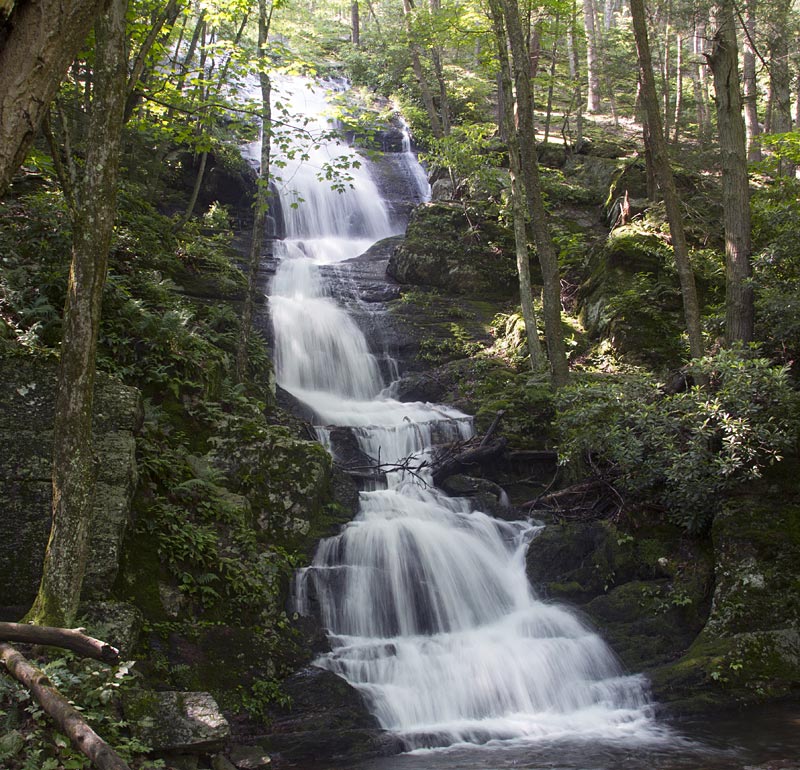
There are 7 other waterfalls you can visit in our state
  1. Buttermilk Falls is your stop if you want to see the state's highest waterfall. At 200 feet, this rocky cascade in the Delaware Water Gap National Recreation Area is a short walk from a parking lot and you can also climb steps to the top for a reverse view. If you're more ambitious, try this hike from njhiking.com
  2. Chikahoki Falls and Otter Hole is in Norvin Green State Forest in Passaic County.
  3. The small Apshawa Falls would be a good stop on a hike through the Apshawa Preserve in West Milford.
  4. Greenbrook Falls has a unique location in the Greenbrook Sanctuary atop the Palisades in Tenafly and Alpine, Bergen County.
  5. The Rockaway River, like the Passaic River in Paterson, once powered industry. Boonton Falls is outside Boonton's downtown in Grace Lord Park.
  6. The prettily named Bridal Veil Falls is on the grounds of William Paterson University in North Haledon. There is a trail behind the falls that lets you stand in a cave behind the falling water.
  7. Tinton Falls is a town and the falls from which it got its name. This Monmouth County waterfall was also one a source of power, and can be easily seen from an overlook off Tinton Avenue.

Thursday, April 14, 2016

The Great Falls Today


Yesterday, I wrote about some of the history of the Great Falls of the Passaic River in Paterson. Today, I'm looking at what is there today.

It is a natural wonder, but it is only 15 miles from downtown Manhattan and surrounded by a very urban and troubled city.

It is New Jersey's newest national park - officially the Great Falls National Historic Park.

We know it for the 77-foot falls that is so often photographed with its arched iron bridge and historic redbrick mill buildings that were once powered by the falls and its raceway system.

The smash hit Broadway musical Hamilton about Paterson's founding father has made Paterson a place to visit if the story intrigues you and you want to dig deeper. The connection between the musical's story and Alexander Hamilton's economic legacy began not in New York City but at Paterson's Great Falls.

Hamilton chose the site of the Great Falls to propel his brainchild, a "national manufactory," Paterson was America's first planned industrial city. In 1791 the Society for the Establishing Usefull Manufactures (S.U.M) was incorporated.

The Great Falls is the east coast's second largest waterfall. Everyone knows #1 - Niagara Falls - and the hope was that New Jersey could pull some tourists to our Great Falls and the surrounding Paterson historic district.

But, just like other natural areas like forests and beaches, and historic areas and wildlife species, the Great Falls needs protection.

The area was named a National Natural Landmark in 1967, a National Historic Landmark District in 1976, And getting a national historic park designation in 2009 helps, but it is not enough.

Last fall, Paterson's Planning Board approved a 156-unit apartment complex atop the ridge overlooking the historic district and falls. Huh? Doesn't that destroy the very thing that you want to promote?

Perhaps the tourism dollars from the park have not come or have not come quickly. Selling land and having construction done is fast and easy money, but will a dangerous half-life to the future.

Short-term tax ratables versus long-term planning and a revitalized Paterson is much more difficult and will take much longer - but will have a much longer and lasting impact on the city, area and state.


Cultural Center at the park

Wednesday, April 13, 2016

Paterson's Great Falls History

Distant view of Passaic Falls.
Distant view of Passaic Falls. by New York Public Library, on Flickr
It was founding father Alexander Hamilton - the current subject of a hip-hop Broadway musical bearing his name - who first imagined how the Great Falls could power industrial development. Hamilton visited the falls in 1778, in the midst of the Revolutionary War, and shared his vision with George Washington and General Lafayette.

After the war, as U.S. treasury secretary, Hamilton selected Paterson to become the nation's first planned industrial city. The water-powered mills produced silk, locomotives and guns, including the first Colt .45 pistols.

Paterson enjoys a distinguished history as one of this nation's earliest industrial centers. It owes its existence to the far reaching vision of one of America's most important founders, and a shaper of our modern governmental and financial institutions, Alexander Hamilton. Hamilton envisioned Paterson, with its water power provided by the Great Falls of the Passaic River, as America's counterpart and response to the industrial revolution occurring in England during the same period.

The history of the City of Paterson includes its beginnings as the ambitious project of Hamilton and the Society for Establishing Useful Manufacturers (S.U.M.) in 1792 at the Great Falls, the early development of water power systems for industrial use, and the various types of manufacturing that occurred in the District's mills into the 20th Century. These included cotton fabrics, railroad locomotives, textile machinery, jute, and silk spinning, weaving, and dyeing, among many others.

The Great Falls also represents compelling stories of the lives of immigrants who labored in the mills, those who owned and operated manufacturing concerns and became wealthy, and the quest of laborers and the labor movement for better working conditions and pay. Immigrants still settle today in Paterson to pursue their versions of Hamilton's vision, creating a diverse and vibrant culture.


Samuel Colt was an early Paterson business owner? From 1836 until 1842, his gun mill produced about 5,000 guns. A lack of government contracts was a major factor in his failure in Paterson. He later achieved success in his hometown of Hartford, Conn., with the outbreak of the Mexican-American War.

Waterfalls and ancient geology, engineering landmarks and the economic birth of a new nation - these are just a few of the things you will discover on your visit to the City of Paterson and the Paterson Great Falls National Historical Park.


Interesting slideshow of vintage Paterson postcards and audio about preserving the city's heritage from The New York Times.

Thursday, January 22, 2015

Following the Lenape Through Irvington and Paterson

I grew up in Irvington, New Jersey and despite its current unsavory reputation, it was a great place to be a kid in the 1950s and early 60s.

It is hard for any of us to really imagine New Jersey 15,000 years ago, but what is now Irvington was then buried under hundreds of feet of glacial ice. As the ice receded present-day contours of the town emerged, such as the Elizabeth River. As a kid, we called that "The Brook" and it's a natural feature that bisects the town from north to south.

The river enters Irvington 140 feet above sea level and gradually descends as it exits the town at Hillside at an elevation of 70 feet. The land east of the Elizabeth River is a gently rolling plain and west of the river is part of the Orange Mountains. The town's little "mountaintop" reaches 220 feet above sea level at Franklin Terrace.

The Lenape (who were later named Delaware Indians by Europeans) were the natives who lived in what is now New Jersey and along the Delaware River in Pennsylvania, the northern shore of Delaware, and the lower Hudson Valley and New York Harbor in New York when Europeans arrived in the sixteenth and seventeenth centuries.

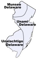
They were the major tribes that lived in our state

The first inhabitants of this Elizabeth River valley were the Awkinges or Hackensacks, who were a subtribe of the Lenni Lenape. I couldn't find any evidence that there was any significant village there, but before Europeans came to the area there was plentiful game and well-stocked streams.

Around 1676, Newark's first settlers spread out towards the "suburbs" and laid out highways. We know that one Lenape trail became Clinton Avenue which ran straight to the Elizabeth River.

The Lenape Trail of today doesn't pass through Irvington or follow a historical American Indian trail exclusively.  Look at a map of the Lenape Trail (which is a component of the Liberty Water Gap Trail). You can see it go through Becker Park with a side trail that goes to to the Walter Kidde Dinosaur Park. The dinosaur tracks there (including the smallest ones ever found) pre-date even the Lenape but it doesn't tell any of our New Jersey natives' story.

The Lenape Trail continues west across the Morristown and Erie Railway tracks and passes under I-280 and continues along Hatfield Swamp and the Essex County Environmental Center before ending at the Patriots’ Path.

The Lenni Lenape people of our area were divided into smaller groups, but all participated in both hunting and gathering as well as cultivation. Deer, elk, bear, fox, raccoon, opossum, muskrat, beaver, squirrel and rabbit were all hunted for food and furs were used for clothing, bone for fashioning tools, toys, and sewing needles. Sinew was used as sewing thread.

Fish leftovers were used as fertilizer. They made maple sugar and had an abundant supply of natural honey. Cultivated garden plots usually contained corn, beans, pumpkins or squash, and tobacco. 

The Minsi  (AKA Munsee) were the "people of the stony country" whose totem was the wolf. They lived in the rugged country along the upper Delaware and their principal village was Minisink, on the east bank at the Delaware Water Gap.

You might know Mount Minsi and Lake Lenape which are located within the Delaware Water Gap National Recreation Area.

They were the largest of the subtribes and most warlike of the Lenape because of their proximity to the fierce Mohawks of the Iroquois nation.

In the Central area of NJ lived the Unami, “the people down the river.”

The southern part of our state was home to the Unilachtigo, “the people who lived near the ocean.”

These were some of the Indians that I read about as a kid in The Last of the Mohicans and the other Leatherstocking Tales of James Fenimore Cooper. I don't think I had any sense that these people had walked over the same lands that I grew up walking over myself.  Many years later, I taught The Light in the Forest in which a European is adopted by a band of Lenape.

The Lenni Lenape people participated in both hunting/gathering as well as cultivation and fishing. In their lands were a great assortment of animals such as deer, elk, bear, fox, raccoon, opossum, muskrat, beaver, squirrel and rabbit. Nothing went to waste. Furs were used for clothing, bone was used for fashioning tools and toys for children as well as being used for sewing needles, and sinew was used as sewing thread.

They spoke what we call an Algonquian language, known as either Lenape or Delaware. Among other Algonquian peoples the Lenape were considered the “grandfathers” from whom all the other Algonquian peoples originated. Consequently, in inter-tribal councils, the Lenape were given the respect one would give to elders.

The Treaty of Easton, signed between the Lenape and the English in 1758, moved them west out of New York and New Jersey and into Pennsylvania. Then they were pushed to Ohio and beyond.

It didn't work to their advantage, but the Lenape were the first Indian tribe ever to enter into a treaty with the United States government. They signed the Treaty of Fort Pitt during the American Revolutionary War and supplied the Continental Army with warriors and scouts in exchange for food supplies.
When the white man arrived, the Lenape had developed an extensive system of trails through the wilderness. These trails were originally 18 inches wide and could only accommodate persons walking in single file. Warriors, messengers, hunters, diplomats and visiting families apparently used separate paths. These Indian paths became bridle trails, wagon roads and twentieth century highways.      via  newhopepa.com
The Lenni-Lenape of New Jersey were peaceful and they were sometimes intermediaries in resolving problems within the nation. The hostile Iroquois mockingly called them “The Old Women.”

North of my hometown of Irvington, the Lenape were also living in what is now the Passaic valley around where I worked for a number of years at Passaic County Community College.

At the Paterson Museum, I learned that the Lenni Lenape Indians knew the Great Falls as a prime camping and fishing site. They called it “Totowa” which meant "to be forced beneath the waters" which shows their respect for the power of the falls.

The Passaic Falls, more popularly known as the Great Falls. There is no record of who first "discovered" the Great Falls. History books record the white settlers who moved into the area following the settlement of Newark in 1666. Of course, the Lenape discovered the Falls long before any white hunters or land prospectors from that colony wandered up the river.

Acquackanonck was the land in lower Passaic County from Essex County line to Pompton. The name is said to be derived from several  Indian words meaning place of brush net + rapid stream. The V-shaped brush nets were set in the river in shallow places so that fish became entangled in the twigs during the seasons when spawning runs of shad and sturgeon were underway.

Over a long period of time, the area of the falls was a productive source of fish for the Indians and later for the white settlers. During the spawning season, shad and other anadromous species (fish that migrate up rivers from the sea to spawn) would come in great numbers to the waters below the falls, where their upstream progress would be stopped.

These large catches couldn't be consumed immediately and much of the catch was dried for later use. Sturgeon, as well as shad, made their way to the foot of the falls and, because of their size, were especially prized. One of the largest ever reported was taken on August 31, 1817, and was said to have weighed 130 pounds.

The Lenape were not the only Indian tribe in this area, but they were the dominant tribe. There is still a group of the Ramapough Lenape Indian Nation (AKA Ramapo Mountain Indians) numbering about 5,000 who live around the Ramapo Mountains of northern New Jersey and southern New York.


Sources

Thursday, January 12, 2012

New Jersey's Newest National Park

Not far from downtown Paterson is is the Great Falls on the Passaic River which recently become America's 397th national park. The National Park designation makes the 35-acre site eligible for federal funds.

The 77-foot waterfall in downtown Paterson is second only to Niagara Falls in terms of water volume east of the Mississippi River.


Alexander Hamilton (lieutenant colonel in the American Revolution, confidant to George Washington, delegate to the Constitutional Convention, and first Secretary of the Treasury) formed in 1792 an investment group called the Society of Useful Manufactures (the “SUM”) whose funds would be used to develop a planned industrial city that was later to be known as Paterson.

Hamilton believed that the United States needed to reduce its dependence on foreign goods and should instead develop its own industries. The industries developed in Paterson were powered by the 77-foot high Great Falls of the Passaic, and a system of water raceways that harnessed the power of the falls. The district originally included dozens of mill buildings and other manufacturing structures associated with the textile industry and later, the firearms, silk, and railroad locomotive manufacturing industries. In the latter half of the 1800’s, silk production became the dominant industry and formed the basis of Paterson’s most prosperous period, earning it the nickname “Silk City.”

 Take a look at the Great Falls from a webcam view via EarthCam and the City of Paterson.

Tuesday, May 5, 2009

The Passaic River Watershed

The Passaic River runs almost 80 miles (129 km) through northern New Jersey.

It starts by winding its way around the swamp lowlands in and around the Great Swamp taking in through tributaries much of the surface waters of northern portion of the state. In its lower portion, it moves through some of the most urbanized and industrialized areas of the state.

The Passaic River formed as a result of drainage from the massive proglacial lake that formed in Northern New Jersey at the end of the last ice age, approximately 13,000 years ago. Glacial Lake Passaic, as we call it now, had its center in the present lowland swamps of Morris County.


The lake rose as the river was blocked, but eventually broke through at the Millington Gorge and the Paterson Falls as the glacier retreated.

Much of the lower river suffered severe pollution during the nineteenth and twentieth centuries because of the development that grew on its banks - in many cases in order to use the river as a resource or as a garbage dump.

The river's health has improved in the past 30 years. Some of that comes from the enactment of the 1972 Clean Water Act and other environmental legislation. Some improvement has come as a result of the decline of industry along the river.

The water quality is still poor. Sediment at the mouth of the river near Newark Bay still registers contamination by pollutants such as dioxin. Dioxin was produced at the Diamond Shamrock Chemical Plant in Newark as a waste product resulting from the production of the agent orange defoliation chemical used during the Vietnam War. The issue of responsibility for the cleanup of the dioxin contamination has been in the courts for decades without resolution.

The Passaic River flows close to my hometown, but even closer is the Peckman River which is one of the many small tributaries. The Peckman River originates in West Orange and flows northeasterly through Verona, Cedar Grove and Little Falls to its confluence with the Passaic River in the borough of Woodland Park (formerly West Paterson).

The New Jersey Department of Environmental Protection (NJDEP) has issued notices banning commercial fishing and advising the general public that fish caught in the tidal Passaic River (from Dunedee Dam to the mouth at Newark Bay) should not be eaten. Still, I see people fishing along the banks - particularly for catfish.

You can access the the Passaic from a number of county parks. It is pretty much free of industrialization until it reaches the Summit/Chatham border. The upper portion before Summit is far more natural in appearance. I have seen canoeists and kayakers there.

When it enters Essex County, there are some natural marsh lands and wooded areas that make it more inaccessible and somewhat protected.

The more heavily populated areas of Passaic County come next with the lower portions of the river south of Paterson being much wider but more industrialized as it flows into Newark Bay.

The Passaic River is known for chronic flooding problems during heavy rainfall or snow-melt. The worst area is where the Pompton River joins the Passaic River in Wayne, New Jersey.

Unfortunately, building has long been allowed in this flood plain. A plan has been proposed for years to build a 20 mile river flood tunnel. The tunnel would divert flood waters directly into the bay. Some riverside residents have already taken buy-outs from the federal government but many people still live within the flood plain.

The Passaic River Coalition (PRC) gives valuable assistance and stewardship for the preservation and protection of over 1,000 miles of waterways including the Passaic River. It was established in 1969.

Their goals include improvements in land-water resource management, and public health issues by working as an advisor to citizens, other environmental organizations, governments, and businesses. They gather scientific data to be used for creating wise management policies. They create maps and graphic displays that illustrate the physical, demographic, and socioeconomic characteristics of the River and its watershed for reports, open space plans, and natural resource inventories.

Their scope goes beyond the Passaic River's banks and into the larger watershed. They have met a Land Trust goal of obtaining 1000 acres by acquiring 34 properties in 6 counties (Passaic, Morris, Bergen, Essex, Sussex, and Somerset).

Protecting the watershed means protecting drinking water, preserving sensitive wildlife habitat, improving water quality, creating new open space, and promoting natural flood control management.

The PRC has been involved in the creation of new surface supply systems such as the Monksville Reservoir and the development of three Water Supply Master Plans for New Jersey. PRC has assisted in plans to restore Greenwood Lake, a primary water source for northern New Jersey and is creating the overall restoration guide for the Lake.

The next challenge is to address the 46 million gallon per day groundwater deficit in the NJ Highlands. You can join the PRC and donate to their fight.


A Great Conveniency - A Maritime History of the Passaic River,
Hackensack River, and Newark Bay


MORE INFORMATION

Sunday, April 19, 2009

Paterson's Great Falls Named National Historical Park


President Obama recently signed into law the Paterson Great Falls National Historical Park Act. The Paterson Act is part of an omnibus parks and historic preservation bill.

Hamilton statue at the Great Falls
photo via Flickr by Ken Ronkowitz

As the nation’s first Secretary of the Treasury, Alexander Hamilton founded the City of Paterson to begin implementing his plan to harness the force of the Great Falls—then the nation’s largest waterfall—to power new industries that would secure America’s economic independence.

Considering that one federal agency has ranked Paterson as the most economically distressed city in the United States, the local community leaders hope the creation of the national historical park, along with preservation and redevelopment of the historic center of the city, will have a positive impact on Paterson’s 175,000 residents.

Groups such as NJ Heritage Development Coalition are recommending that the state enact a state historic preservation tax credit that will jump start redevelopment in Paterson and across the state.

President Barack Obama’s Remarks
"As Americans, we possess few blessings greater than the vast and varied landscapes that stretch the breadth of our continent. Our lands have always provided great bounty – food and shelter for the first Americans, for settlers and pioneers; the raw materials that grew our industry; the energy that powers our economy.

What these gifts require in return is our wise and responsible stewardship. As our greatest conservationist President, Teddy Roosevelt, put it almost a century ago, “I recognize the right and duty of this generation to develop and use the natural resources of our land; but I do not recognize the right to waste them, or to rob, by wasteful use, the generations that come after us.”

That’s the spirit behind the bipartisan legislation I’m signing today – legislation among the most important in decades to protect, preserve and pass down our nation’s most treasured landscapes to future generations."