Showing posts with label Morris County. Show all posts

Monday, August 4, 2025

The New Jersey Highlands

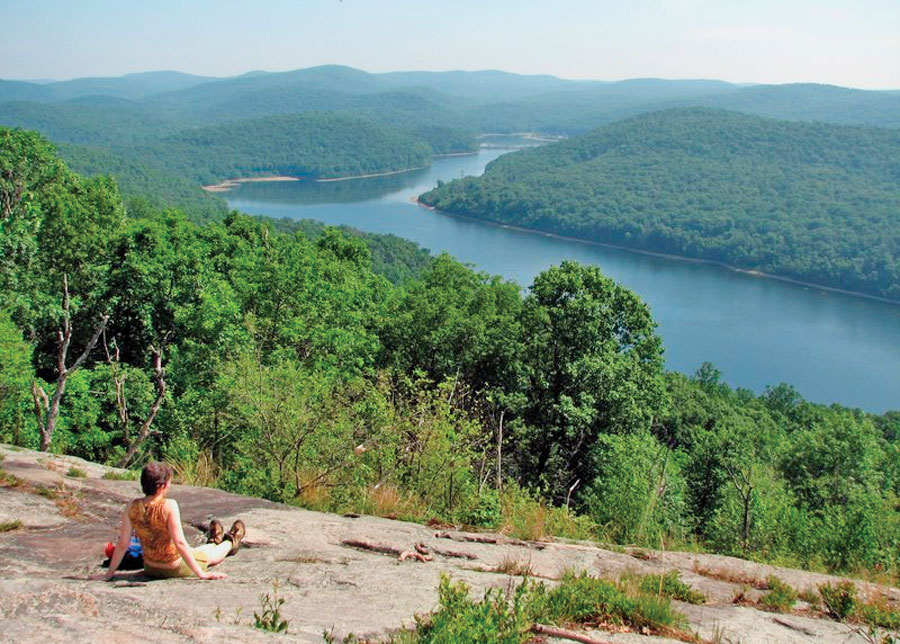
The Highlands of New Jersey is one of those areas that people from other parts of the country just don't associate with NJ. (The Pinelands is another area like that.) The forested ridges, rocky cliffs, and the streams, lakes, ponds, and reservoirs for fishing and recreation are all there. 

The Highlands covers 840,000 acres and includes 188 municipalities. There are 7 Highlands counties – Bergen, Passaic, Morris, Sussex, Warren, Hunterdon, and Somerset – and all contain a diversity of forests, wetlands and grasslands. That habitat diversity is also home to threatened and endangered wildlife.

There are 72 New Jersey-listed endangered, threatened, and rare animal species, including mammals, birds, amphibians, reptiles, butterflies, dragonflies, damselflies, and mussels, and two species (the Indiana bat and bog turtle) are Federally-listed. There are also 137 endangered, imperiled, and rare plant species.

The Highlands also contains historic structures and archaeological heritage sites that need protection.

Hikers can find miles of trails, including both the Appalachian Trail and the Highlands Millennium Trail.

For over half of New Jersey’s residents (4 million+), the Highlands is a critical area for their drinking water. The NJ Highlands Water Protection and Planning Act was passed in 2004, dividing the 840,000-acre region into a “Preservation Area” with strict NJDEP regulations and mandatory Regional Master Plan conformance, and a “Planning Area” with voluntary Plan compliance.

As is often the case in NJ, suburban sprawl is the greatest threat to the Highlands’ drinking water supply, and to the forests, farms, wildlife habitat, and historic, recreational and scenic resources.

There are several areas in NJ that are a focus for Highlands Coalition.

The Wyanokie and Farny Highlands (Passaic and Bergen) contain unprotected lands in nearby Wanaque and Split Rock reservoirs that would connect existing State and county parks and forests in these two heavily utilized recreational areas. This focal area was ranked highly due to its value for water resources and recreation, and secondarily for biodiversity and forest land.

The Pequannock Watershed (Morris, Passaic, and Sussex) serves as the core of the northern New Jersey Highlands and serves as a major hub connecting existing open space areas. This focal area was ranked highly due to its multiple values for water resources, forest land, biodiversity, and recreation.

The wooded ridges of Sparta Mountain/Lubber’s Run (Morris and Sussex) provide an important greenway corridor connecting Mahlon Dickerson Reservation in the north and Allamuchy Mountain State Park in the south. Major gaps in conservation protection include the nearby areas of Mase Mountain. This focal area was ranked highly due to its value for productive forest land, biodiversity, and recreation.

Upper Pohatcong/Pequest area (Warren) also contains forested ridges and wetlands centered around the Pequest Wildlife Management Area, which serve as an important groundwater recharge, wildlife habitat, and outdoor recreation area. This focal area was ranked highly due to its value for water resources and recreation and secondarily for its productive forest and farmland.

Scott Mountain/Musconetcong Ridge in Warren and Hunterdon counties and the neighboring productive farmland of the Delaware, Pohatcong, and Musconetcong valleys form a large contiguous area of high-quality rural landscape. This focal area was ranked highly due to its value for biodiversity and productive farmland, and secondarily for forest land and recreation.

MORE

Wednesday, July 23, 2025

NY & NJ Trails

You can enjoy some excellent hiking trails and hikes within or just a day-trip away from New Jersey. People from other parts of the country (and, unfortunately, a lot of people in NJ) find that surprising.

Since 1920, the New York-New Jersey Trail Conference has partnered with government and private landowners to create, protect, and maintain a network of 1,700 miles of hiking trails in the New York-New Jersey metropolitan region.

The Trail Conference is a volunteer driven not-for-profit organization with a membership of 10,000 individuals and more than 100 clubs.

Want to take an easier hike and see waterfalls? Try They have a nice online search tool for finding hikes by difficulty (Easy, Moderate or Strenuous) or by Views and Features like waterfalls.

Hedden County Park in Morris County, NJ an easy 3.2 miles hike that includes a waterfall - or - try Falling Waters and Grand Loop Trails at Schooley's Mountain County Park (also Morris County) which is just 2.5 easy miles with a waterfall view.

Want more of a workout and also a hike you can take public transportation to instead of your car?

Horse Pond Mountain Loop at the Long Pond Ironworks State Park is 6 moderate to strenuous miles. Crossing a causeway over the Monksville Reservoir, you'll pass the historic buildings of the Long Pond Ironworks on your way.

The Trail Conference can even provide the best map for the hike.

Monksville Reservoir from Horse Pond Mountain

Thursday, January 30, 2020

Hatfield Swamp


The Hatfield Swamp is a place I often pass in my local travels. "Swamp" is not a word that cries out for you to plan a visit, so let's more accurately and kindly say that this is a freshwater wetland area.

It forms what is sometimes referred to as the "second bank" of the Passaic River at the border area between Morris and Essex counties.

The area of Hatfield Swamp is approximately 2,500 acres (10 km2), located in northern New Jersey at Latitude 40.85 N and Longitude 74.32 W.

The Swamp is part of West Essex Park and there are trails for public hiking. The Essex County Chapter of the Sierra Club and the New Jersey Audubon Society lead trips throughout the swamp in all seasons. A good starting place to explore and get information is the Essex County Environmental Center.

At the western end of the swamp, the Whippany River connects to the Rockaway River. The Rockaway River then travels a short distance into the center of the swamp where it flows into the Passaic River.

After heavy rain and if there is spring snowmelt, Hatfield Swamp floods since three rivers join here.

For animal observation, the area isn't always conducive due to the flooding. Deer, raccoons, possums, skunks and fox all live in the area (West Essex Park) but generally in the less swampy edges the swamp itself where there is higher and drier ground. We might expect to find muskrats there but the flooding would fill their bank dens with water and the area is also not conducive to plant foods that muskrats favor.

In autumn, waterfowl passing through the area rest in the swamp before proceeding south.

This wetlands area is not a place for some tree species (mostly hardwoods), but you will find various oaks, maples, sweet gum, and elm trees. (Find out more about plants found here)

Unfortunately, the three rivers that meet here were all once highly polluted. Things are better today but pollutants that remain in the soil and water have affected flora and fauna. The fish that are most likely found in the Rockaway River and Whippany River are carp and catfish.

Some history: Cornelius Hetfield owned and operated a mill at some point here before the American Revolution. Hetfield was a Loyalist during the Revolution, so his property was eventually confiscated. It was later purchased by Cyrus Crane. It stayed in the Crane family into the 1960s. The mill was dismantled and moved to Allaire State Park in Monmouth County and the swamp area of the park reverted to a slightly modernized Hatfield Swamp.

But let's go way back in Hatfield geologic time. It was the late-Triassic/early-Jurassic and when the North American plate separated from the African plate and created a rift valley. Today we refer to that rift as the Newark Basin. This valley changed over the next few millions of years, the valley faulted, tilted, and eroded and eventually the basalt layers formed ridges.  Then the Wisconsin Glacier ice sheet during the last ice age advances and plugs the gap with its glacial rubble. The glacier melts and the water pools up behind the ridges. The ridges are our Watchung Mountains and the pooled water forms Glacial Lake Passaic. Go forward thousands of years and the lake drains leaving behind swamps. The big one is our Great Swamp which drains from that Passaic River and flows through a gap in ridges passing through Hatfield Swamp.

If you want to visit, an easy starting place is the Essex County Environmental Center, which is in West Essex Park.  This site (download small map) was once a tavern and stagecoach stop, and the nearby bridge over the Passaic River is where Morris County’s historic Patriots Path connects with the Lenape Trail in Essex County.


Wednesday, August 22, 2018

New Jersey Revolutionary War Sites: Morristown, New Jersey


Jockey Hollow was used as a campsite by 10-12,000 soldiers during the winter of 1779-80, while Washington was headquartered at Ford Mansion. It was a brutal winter and the soldiers experienced great hardship, hunger, and cold.

28 separate snow storms fell during the winter, and it was so continuously cold that, for the only time in recorded history, the waters around New York City froze over, and were closed to shipping for weeks at a time. In the midst of these extreme weather conditions, the soldiers had to build their own huts, and endure a serious shortage of food.

Morristown has a number of historic sites related to the Revolutionary War.

"The Green" has been and still is the center of Morristown and when General Washington took his headquarters at the Jacob Arnold tavern during the 1777 winter encampment, the Green became a hub of military activities.

Various buildings around it were used as officers' headquarters, army hospitals, and a military storehouse. There are historic plaques which describe buildings and churches that stood around the Green at the time of the Revolutionary War. Opposite the Arnold Tavern site on the North Park Place side of the park, is a monument to mark the site of the courthouse and jail that stood here at the time of the Revolutionary War.

There are a group of life-size statues of George Washington, Alexander Hamilton and the Marquis de Lafayette there. Another sculpture is called Patriots Farewell that sits atop a fountain on the West Park Place side of the park and shows a militiaman saying farewell to his wife and son, accompanied by their horse and dog. The plaque reads: "A monument to the New Jersey militia and their families whose sacrifices created a strong and enduring nation."

The Green is a great place to visit during a day of local sightseeing.

There is also a location known as Fort Nonsense. The name applied to the Upper Redoubt but may not have a basis in actual Revolutionary War era history. Apparently a story arose circa the early 1800's that Washington only had these fortifications built as a way of keeping his troops busy, and therefore the fort was a work of "nonsense." The name stuck and it is now used as the official name for this part of the Morristown National Park.

Cannon at Fort Nonsense - Wikimedia
During the winter 1777 Morristown encampment, this was the site of the Upper Redoubt, on top of what was then called Kinney's Hill. (A redoubt is an enclosed defensive fort, usually constructed from earthworks.) On May 28, Washington's last full day in Morristown in 1777, he wrote several letters and orders, including one to Lieutenant Colonel Jeremiah Olney. In it, he refers to the Upper Redoubt, the Guard House, and the "The Hill" on which they sat. These orders make clear that Washington had a serious reason for the structures.

While none of the original structure survives, an outline of the original fortifications (based on archeological evidence) is marked out in stones. There are a number of historical plaques here to explain the events connected to the area.

More information at revolutionarywarnewjersey.com

Friday, February 16, 2018

Winter in Morristown with General Washington


In January 1777, General George Washington set up winter headquarters for himself and the men of the Continental Army. He was fresh off two significant victories over the British in Trenton and Princeton, New Jersey. 

The army had marched north to Morristown, New Jersey, where the hills surrounding the camp offered a good vantage point to observe the the British army which was headquartered across the Hudson River in New York City. 


Morristown’s position allowed Washington to protect the roads leading from the British strongholds in New Jersey to New England and the roads leading to Philadelphia, where the leaders of the American Revolution were headquartered.

Morristown was actually the location of two winter encampments during the Revolutionary War. Washington had first visited Morristown in 1773 with his stepson John Parke Custis. He had been passing through the town en route to nearby Basking Ridge to visit William Alexander, Lord Stirling, who would later become a major-general in the Continental Army.

Morristown National Historical Park commemorates the sites of General Washington and the Continental army’s winter encampment of December 1779 to June 1780, where they survived through what would be the coldest winter on record. The park also maintains a museum & library collection related to the encampments & George Washington, as well as items relating to pre- and post-Revolutionary America.

Reproductions of soldier cabins

Washington used some of the winter trying to reorganize and build up the Continental Army. Despite the Trenton and Princeton victories, some soldiers chose desertion over another cold winter without adequate supplies. Reenlistments were down and soldiers were returning home when their enlistments expired.

For five months, Washington maintained headquarters at Arnold's Tavern on the Green which was - and still is - the central hub of Morristown society.

Washington ordered inoculations for his militiamen during a smallpox outbreak in February of 1777 and he was very concerned with personal and public cleanliness. Nevertheless, his troops were so distressed by the disease and poor conditions of the camp that by spring 1777, many men attempted to leave and were charged with desertion.


Ford Mansion (Photo: Rob Shenk on Flickr)

Washington returned with his troops between December 1779 and June 1780 at a second encampment in a section of forest known as Jockey Hollow. The winter was bitter. He was accompanied by his wife Martha, and they were given shelter in the Ford Mansion owned by Colonel Jacob Ford, Jr. and his wife, Theodosia.

The Georgian style mansion, built in 1774, that was Washington's headquarters, is now part of the the Morristown National Historical Park.

As of January 1, 2018, the park will no longer charge a daily entrance fee, so coniser a winter visit of your own.

MORE 


Wednesday, January 24, 2018

A Dangerous Time for Hibernating Bats

You may be spending more time indoors now that it is winter, but New Jersey's non-migrating bats have gone into hibernation. It is a dangerous time for them no, particularly because of white-nose syndrome. This is caused by a fungus that was originally introduced inadvertently by humans exploring caves in New York State.

The disease has decimated many bat species. It scars their wings and disrupts their hibernation patterns. One of its effects is that it causes them to wake and fly around when they should be sleeping, and so their energy reserves deplete and they die from starvation, thirst and exhaustion.

Bats are the single largest consumer of night-flying insects like mosquitoes, beetles and moths. Not only does that help humans be less bothered outdoors in the summer and decrease the spread of mosquito-borne diseases, but it this natural insect control helps our Garden State agriculture.

A little brown bat with white nose syndrome.
The most affected of New Jersey's bats is the little brown bat which was once common but has now become rare. NJ's largest hibernaculum is the old Hibernia Mine in Morris County. Before the syndrome hit our state in 2007, Hibernia was the winter home for 34,000 little brown bats. Now, there are only about 400.

The best we can say currently is that this small population seems to be leveling off.

Big brown bats seem to be unaffected by white-nose syndrome and it may be because they hibernate in different locations than the little brown bat. They prefer cold but dry places, such as attics. (If you discover bats in your attic or home, don't try to remove them on your own. Call a bat removal expert, who can safely remove them.) Caves tend to be warmer and have higher humidity which may increase the fungus spreading. When the big brown bats do use subterranean locations, they stay close to entrances where it is colder. They may, if the weather warms enough, even awaken, seek water and perhaps breed.

Modifications in the Hibernia cave to increase air flow may drop temperatures slightly, inhibiting the growth of white-nose fungus.

Little brown bats, northern long-eared bats, tri-colored bats and eastern small-footed bats are all affected by white-nose syndrome, and have been recommended for inclusion on the state's endangered species list.


More on New Jersey's bats
http://wildlife.rutgers.edu/bats/
http://www.conservewildlifenj.org/protecting/projects/bat/white-nose/
Bat Conservation International www.batcon.org.

Wednesday, June 14, 2017

And in New Jersey Bobcat News...

Wildlife on Hidden Camera” by USFWS

This month I saw a few unusual New Jersey animal sighting stories in the news. One was a
"mystery animal" sighting in Ewing Township that was probably a fox that has shed its fur. Another was a news story about a bobcat that entered a house in Washington Township.

Bobcats typically avoid humans, so the incident is unusual. But bobcat sightings and encounters are on the rise in NJ. Later, in another part of the township, a bobcat attacked and injured a dog, and then a half hour later, police received a call that the bobcat was in a nearby barn.

Conservation officers snared the animal because they believed it was showing possible early signs of having rabies and it was removed by the Division of Fish and Wildlife for observation and possible testing.

Native New Jersey bobcats were almost extinct in New Jersey in the 1970s, but thanks to ongoing conservation efforts have been making a slow comeback.

Bobcats roam an average of seven miles a day, so they require lots of land. Car strike deaths is the leading cause of bobcat mortality in the state.

Having connected wild habitat for them is the best situation for them and would decrease their entry into populated areas, but that is a difficult task to accomplish in our densely populated state.

The Nature Conservancy in New Jersey is working to protect "Bobcat Alley," a 32,000-acre corridor of connected and protected habitat in northwestern New Jersey.


Bobcat infographic via www.nature.org  click link for larger original 

Monday, February 13, 2017

Plan to Cut Trees in Sparta Mountain Wildlife Management Area Becomes Controversial


The NJ Department of Environmental Protection, in conjunction with the New Jersey Audubon Society, have put forward a plan to cut roughly 20 to 30 acres on Sparta Mountain annually. Opponents of the state’s plan to cut acres of trees in the Sparta Mountain Wildlife Management Area have come out strongly against the plan.

The state feels it is necessary to cut timber in order to diversify the forest and create “young forest habitat” that endangered species in the area need to thrive.

Opponents see the plan as a logging scheme disguised as a forest stewardship plan. They also feel that removal of the trees threatens an area of land that provides a large percentage of water for the state.

The anti-logging effort has been branded with the name “Stop the Chop” by the group SaveSpartaMountain.org.

A meeting in late January at the Franklin Firehouse was sponsored by the Friends of Sparta Mountain group, which included environmental speakers as well as Sen. Raymond Lesniak (D-Elizabeth).

The plan would encompass 3,400 acres of land within the townships of Sparta, Ogdensburg, and Hardyston in Sussex County and Jefferson Township in Morris County.


Monday, May 4, 2015

Coyote Sightings and Attacks Increasing


There has been an increasing number of media stories about coyotes in New Jersey because of an increasing number of coyote sightings and encounters.

Bergen County residents have actually been attacked by aggressive coyotes several times since last fall and two people have been bitten by coyotes this year. Most recently, officials shot and killed a coyote suspected of attacking a county resident near a wooded area in Norwood. A nearby K-8 school canceled outdoor athletic practices and instituted an indoor recess policy for the remainder of the week after two coyote dens were found near school grounds.

There were also reports of coyotes in Harrington Park and in Ridgewood a coyote was seen lurking around the Willard Elementary School area (though neither was found).


The first sighting of a coyote in New Jersey was in 1939, but official sightings have been irregular in the years since. They are now reported in almost 400 municipalities across all 21 of the state’s counties, with a population estimated at 3,000.

Coyotes are adaptable to humans and generally stick to rodents, rabbits and sometimes small deer for food. They rarely attack humans, but recent incidents include coyotes investigating humans walking dogs and dogs alone in backyards. Increased fear comes from several cases in which the attacking coyote has been found rabid.

On the night of April 30th, a coyote grabbed a Yorkshire terrier in a backyard and retreated to the woods with it in Randolph Township.

New Jersey and New York City residents are reporting an increased coyote presence this spring.


Monday, January 26, 2015

Walking the Columbia Trail

Pequest Trail at DL&W overpass

Most of us will never through hike the Appalachian Trail and only a small group of us will even hike the New Jersey section of the AT, but there are many smaller and short trails in the state that are good for beginners, parents with kids and a day's outing.

I have written about the Columbia Trail which is a Rails-to-Trails project which in Morris County follows the South Branch of the Raritan River. It ends to the north at Long Valley near the nearby Patriots' Path trail.

When in the 1990's the Columbia Gas Company constructed a gas line under the rail bed, the surface rights were transferred to the Hunterdon County Division of Parks and Recreation for use as a recreational trail.

There are a number of other smaller trails near sections of the Columbia Trail.

The Columbia was the Trail of the Month last October on the TrailLink website. They discovered that the Columbia Trail "had the highest user rating that a trail could have: five out of five stars, as well as 70 firsthand reviews when most trails on the site boast only a handful. It ranks number 21 on the list of TrailLink's most-viewed trails in the entire country."

Columbia Trail along the Ken Lockwood Gorge, photo © Sean Blinn via railstotrails.org

Information on Rails-to-Trails via http://www.traillink.com

Monday, August 18, 2014

Learning About New Jersey's Great Swamp


The Great Swamp was created approximately 15,000 years ago. The Wisconsin Glacier pushed its way during the Ice Age and in its melting poured into the natural basin known as the Passaic Valley to form Glacial Lake Passaic.

What we call the Great Swamp is what remains of that huge lake which has continued to drain via the Passaic River and many other smaller rivers and creeks.


If the name Great Swamp doesn't sound like an appealing place to visit, you need to look beyond the name. It is not entirely swampland but rather a mixture of marshes, meadows, dry woods and brush-covered swamps.

These four habitats are what make the Great Swamp unique and allow the area to support a wide variety of plant and animal life.

The Great Swamp is one of NJ's 5 National Wildlife Refuges. Their website offers this advice to visitors:

People are encouraged to observe, study, photograph and walk with nature in designated public areas. The best times for observing wildlife are early in the morning and late afternoon. Because of large number of visitors in the spring and fall, wildlife viewing on Sundays is often less rewarding. The refuge has close to 10 miles of foot access trails, with varying difficulty from which wildlife can be viewed. There are also three wildlife observation blinds and one wildlife overlook. Pleasant Plains Road is a good place to view wildlife from your vehicle. The Great Swamp National Wildlife Refuge also recommends that you visit the Raptor Trust (for information please call 908-647-8211), the Somerset County Environmental Educational Center (for information please call 908-766-2489) and the Morris County Outdoor Education Center (for information please call 973-635-6629). There is also the Watchung Reservation, Morristown Historical Park, Sherman Hoffman Aubudon Center and several other outdoor recreation areas located close to the Great Swamp National Wildlife Refuge.

Frelinghuysen ArboretumIf you visit, there are well maintained trails and even boardwalks that allow you to observe without doing harm to the habitat. (This is not a place to bring pets.)

Plants vary in size from the tiny duckweed to the towering red oak. As the seasons change, so does the color of the area - yellow marsh marigold to the blue iris.

One way to learn more about this living, breathing botanical and zoological resource is with a visit to the Great Swamp Outdoor Education Center. which is part of the Morris County Park Commission and offers many environmental programs for all ages.

 If you live in the area, you may want to become involved in the volunteer opportunities there too.

Download the refuge brochure (pdf)

Sunday, September 15, 2013

BUTTERFLY RAMBLE AT BAMBOO BROOK

BUTTERFLY RAMBLE AT BAMBOO BROOK
DATE: Sunday, September 22  Butterfly
TIME: 1 - 4 p.m.
PLACE: Bamboo Brook Outdoor Education Center, Far Hills
DETAILS: This is a great time to see the monarch butterfly migration and late season wildflowers! This event is led by naturalist Blaine Rothauser and members from the North Jersey Butterfly Club.  The walk one of several activities taking place at the Morris County Park Commission's open house at Bamboo Brook Outdoor Education Center.
COST: Free
REGISTRATION: Advance registration requested but not required. To register online, go to https://donate.njconservation.org/2013-butterfly-ramble 

Saturday, September 7, 2013

New Jersey Wild Turkey Population Increasing


Male Eastern Wild Turkeys (Meleagris gallopavo silvestris)
Photo: KenThomas.us via Wikimedia

Several news outlets reported last week that a wild turkey smashed through the window of a Smoke Rise, NJ home and caused $5,000 in damage before smashing another window to escape pursuing police officers.

Due to its size, the suspect was assumed to be a male turkeys, referred to as toms and gobblers, which are much larger than the female hens. The average wild turkey weighs in at 20 lbs compared to the domestic variety which can be as large as 15-30 lbs. Domestic turkeys can be identified by their black legs, while wild turkeys have pink legs.

Wild turkeys are occasionally aggressive and have been known to peck at windows, automobile mirrors or reflections in shiny surfaces such as polished cars.

Wild turkeys had been extirpated from New Jersey by the mid-1800s because of their use as food and increasing loss of habitat. But the efforts to reintroduce them with 22 birds in 1977 were so successful that we now have an abundance of them throughout New Jersey. They have been moving more frequently into suburban neighborhoods. (I see them regularly in my own west Essex County town.)

The current population is estimated at 20,000 to 23,000.

Wild turkey hen with poults (chicks)           Photo: Kevin Cole via Wikimedia

Rafters (flocks of turkeys) are more commonly seen in rural areas of the state. Wild turkeys are omnivorous, foraging on the ground or climbing shrubs and small trees to feed. They prefer eating acorns, nuts, and various trees, including hazel, chestnut, hickory, and pinyon pine as well as various seeds, berries such as juniper and bearberry, roots and insects. Turkeys also occasionally consume amphibians and small reptiles such as lizards and snakes. Poults (chicks) have been observed eating insects, berries, and seeds. Wild turkeys often feed in cow pastures, sometimes visit back yard bird feeders, and favor croplands after harvest to scavenge seed on the ground. Turkeys are also known to eat a wide variety of grasses.

Turkey populations can reach large numbers in small areas because of their ability to forage for different types of food. Early morning and late afternoon are the desired times for eating.During harsh winters, they can survive up to two weeks without eating, but will move into more populated areas.

Turkeys are neither endangered or threatened in NJ. Legal hunting of wild turkeys is regulated by the State Division of Fish, Game and Wildlife. The NJ fall turkey hunting season is from October 26– November 2, 2013.

Wild turkeys evolved on the North and South American Continents exclusively and became a great game bird for Indians and settlers. Indians of the American Southwest, Mexico and Central America first hunted the wild turkey and also domesticated them. Spanish Explorers enjoyed them so much they took Mexican turkeys back to Europe in the 1500s.

New Jersey State Chapter of the National Wild Turkey Federation


Wednesday, July 31, 2013

Bobcat Sightings More Frequent in New Jersey

Bobcat seen on a trail camera near Blairstown, Nov. 2011 via nj.com

A sighting this week of a bobcat in Boonton reminds residents that this endangered species exists in New Jersey and is making a comeback.

These cats, much larger then house cats and with tufted ears, are rarely seen by humans. They prefer to live in isolated large wooded and rocky areas away from homes.

The bobcat seen in Boonton Township was near the Splitrock Reservoir and is an area where deer, foxes, bears, and coyotes are not unusual sightings.

There have been a number of bobcats spotted in the area around the Picatinny Arsenal, a state zoologist told the Daily Record but they are most frequently found north of Route 80.

It seems that they are moving to other sections of Morris County. Although the bobcat population of this native NJ species is climbing in the state's northern region, they remain endangered in New Jersey.

The bobcat is a medium sized-cat, about two feet tall. It is larger than a housecat, but much smaller than the big cats like a cougar or lion. Adult females in NJ generally weigh between 18 and 25 lbs. while adult males can weigh as much as 35 lbs. Their fur ranges from yellowish brown to reddish brown and bears markings that vary from ‘tabby’ stripes to heavy spotting. They possess slightly tufted ears and a short bobbed tail (between three and seven inches long) that is black above at the tip. Generally they hunt both by night and day, although there is evidence to suggest that most hunting takes place at dawn and dusk.

The NJ Division of Fish and Wildlife conducted a restoration project where 24 bobcats captured in Maine were released in northern New Jersey from 1978-1982. By the 1990’s reports of bobcat sightings began to increase. Today, bobcat reports from northern NJ are on the increase. Unfortunately, so are the numbers of bobcats killed by automobiles on our highways. During a one year period between 2008 and 2009, fourteen bobcats were observed on NJ roads and ten of these were hit by cars.

Bobcat feeding via wdfw.wa.gov


More info:  http://www.nj.gov/dep/fgw/ensp/pdf/end-thrtened/bobcat.pdf

Tuesday, June 18, 2013

Preservation New Jersey’s Ten Most Endangered Historic Places 2013

Each year, Preservation New Jersey releases a list of their "Ten Most Endangered Historic Places"in our state as a way to build awareness for landmarks and historic resources that are in danger of disappearing.

As with animal and plant species, sometimes the average person will look at items on the list and wonder why they are worth saving. So, educating the people of that area and in NJ is an important part of this preservation and conservation process.

Places listed as "most endangered" have architectural and historic integrity coupled with an identified threat to their existence.

Illustration of Inclined Plane 11 East in Bloomfield from Scientific American, May 20, 1882. The house in the upper-left represents the Collins House, but is not an accurate depiction of the house’s location. via Collins House photo gallery


In my own Essex County, the 18th century Collins House in Bloomfield is one site that is historically and architecturally significant. It is one of the earliest houses built in Bloomfield and the only one that survives in its original open space landscape.

Very few of these "East Jersey Cottages" are left and it also has ties to local transportation and industrial history by way of the Morris Canal and the adjacent paper mill.

The Morris Canal Rockaway River Aqueduct, in Denville, also made the list because of the threat of demolition.

Collins House has been vacant since 2005 and is in poor condition and the Township of Bloomfield considers the house beyond restoration. But The Friends of the Collins House was formed to protect and raise awareness about the house.

image via www.preservationnj.org
It's a situation that is typical of historical preservation projects. The biggest problems are often not the actual physical preservation process itself, but the lack of public awareness about the significance of the place, a lack of support from the municipality, county or state and a lack of funding.

The Morris Canal Rockaway River Aqueduct is located on Diamond Spring Road, in Denville Township, Morris County. It is already part of the Morris Canal Historic District and is listed on the New Jersey and National Registers of Historic Places.

What remains of the components of the canal structure (masonry piers and abutments) are threatened with demolition by Denville Township in an attempt to alleviate flooding along the Rockaway River. It's not even clear about the ownership of the aqueduct site.

Groups like Preservation New Jersey acknowledge that consideration has to be given to serious flooding, but wants options that do not require a loss of historically significant elements. They point to similar structures, such as the Mule Bridge Pier in Boonton, that were saved and restored, and enrich the community's history.

Monday, January 7, 2013

The Columbia Trail


Rails-to-Trails Conservancy is a non-profit organization whose mission it is to create a nationwide network of trails from former rail lines and connecting corridors to build healthier places for healthier people. One of NJ's rail lines that became a trail is the Columbia Trail in rural northwestern New Jersey. It was created from portions of the former Central Railroad of New Jersey High Bridge Branch.

The trail runs from High Bridge, in Hunterdon County, to Flanders, in Morris County. The trail is 16.2 miles (26.1 km).

The Columbia Trail is relatively flat and since it was a rail bed it consists mostly of fine crushed stone. It provides passive recreation to the surrounding communities through hiking, biking, and cross country skiing.

In Morris County, it parallels the South Branch of the Raritan River. At the northern terminus is Long Valley where the nearby Patriots' Path.

A notable portion of the Columbia Trail is the Ken Lockwood Gorge, between Califon and High Bridge (2½ miles north of High Bridge). The South Branch of the Raritan River parallels the trail through the gorge, and this is a scenic walk along this small river. The fast-flowing river is very popular for fly fishing. There is a 60-foot (18 m) trestle that carries the trail over the river in the gorge.

There is little evidence of the trail's railroad past, but a  small section of track is preserved in Califon and a small and rarely open museum dedicated to the rail line history is located in the preserved train station in the town center.

The original rail line accommodated passengers, but was known more for its shipments of iron ore from the mines in Morris County. A spectacular train wreck occurred on April 18, 1885 when Engine #112 (known as "The Columbia") and 45 cars plummeted off a 60' wooden trestle into the South Branch of the Raritan River. The wooden trestle was replaced by steel piers in 1930 and is now known as the Ken Lockwood Gorge Bridge. The last passenger excursion occurred in 1935 and the last freight train ran on April 1, 1976.

In the mid 1990's, the Columbia Gas Company of West Virginia constructed a gas line under the rail bed. The surface rights were then transferred to the Hunterdon County Division of Parks and Recreation for use as a recreational trail.

along the South Branch Raritan River through Ken Lockwood Gorge.

Parking and Trail Access
To reach the west, or High Bridge, end of the trail from I-78, take the exit for State Route 31 North. Turn right on West Main Street. After crossing under the railroad tracks, turn left. Trailhead parking is on the left just past the borough hall.

To reach the east, or Long Valley, end of the trail, from I-287, take the exit for US 206/202 North. Bear left to remain on US 206. Turn left onto SR 24. Follow SR 24 by turning right onto Schooleys Mountain Road. The trailhead parking lot is on your left.


MORE INFO
http://www.co.hunterdon.nj.us/depts/parks/ParkAreas/ColumbiaTrail/info.htm
http://www.traillink.com/trail/columbia-trail.aspx

Images: http://commons.wikimedia.org

Tuesday, August 28, 2012

New Passive Recreation Area for Washington Township

The New Jersey Conservation Foundation announced that it has purchased a 44-acre property in Washington Township. This will add to more than 1,000 acres of preserved farmland and open space already in the Schooley’s Mountain area,

The property was purchased using funds from the Morris County Preservation Trust, the Victoria Foundation, the state Green Acres program and the Washington Township Land Trust.

This is land that is the “special environmental zone” designated in the Highlands Regional Master Plan. That gives it the highest priority ranking for preservation as part of the plan's attempt to protect the region’s water supply. The South Branch headwaters, Schooley’s Mountain and Musconetcong Mountain are all recognized as “Highlands Critical Treasures” by the Highlands Coalition.

The Teetertown Brook runs through the property and it is a tributary of the South Branch of the Raritan River which is a water-supplying river. headwater streams that lead to the South Branch of the Raritan River, which serves as a source of drinking water for more than 1.5 million New Jersey residents. The South Branch is also a valuable trout production area that flows to a major drinking water source, the Spruce Run Reservoir.

The property will be open to the public for “passive recreation” which can include hiking and nature observation. The area is habitat for several endangered and threatened species, including the bobcat, barred owl and longtail salamander.

Saturday, February 25, 2012

Endangered or Just In Danger Amphibians and Reptiles

A yellow spotted salamander changing lanes

If the unusually warm weather and crocuses blooming in your garden haven't been harbingers of spring, then note that the amphibian migration has begun across a good part of New Jersey.

With the rain yesterday being just about the right temperature, some eager salamanders and frogs are moving to their breeding pools.

Unfortunately, our "Garden State" is also a highway state and crossing is quite dangerous for those creatures. There are some people out there helping out, but keep a watchful eye when driving on rainy nights if you can.

An article in The New York Times, "Bucket Brigade Gives a Lift So Salamanders Can Live to Mate", describes one group of "salamander people" in Mississippi  are out on these rainy, early spring nights scooping up salamanders to help them cross the road. These "herpers" who search for and aid the amphibians or reptiles do their part to try to protect endangered, threatened and just plain in danger creatures.

Some salamanders can live up to 30 years, so they have been down this road (well, really, across this road) before. But they procreate only once a year.

I have written earlier here about similar projects in New Jersey. Saving other, more lovable species might be easier to get attention, volunteers and funding.

The NJDEP, Division of Fish and Wildlife’s Endangered and Nongame Species Program (ENSP), the Conserve Wildlife Foundation of NJ, and the NJ Audubon Society have been partners on the Amphibian Crossing Survey Project. Since 2002, they have been working to protect early-spring breeding amphibians like the wood frog, spotted salamander, jefferson salamander, and spring peeper during their annual migrations, which often lead them across perilous roadways. Volunteers help monitor sites in northern NJ (resources are limited, so that has been the focus area) particularly Warren, Passaic and Morris County. But they also help to identify additional crossings throughout the state.

A single vehicle can crush dozens of the slow-moving animals as they try to cross the road during migration. For example, some major amphibian road-crossings occur in West Milford in Passaic county. On rainy evenings from late February through March, teams of volunteers will be serving as “Crossing Guards” - slowing traffic, moving amphibians across the road, and collecting data about the migration.

According to the ENSP, amphibians are regarded by many scientists as indicators of a region's health and as the first indicators to harmful environmental changes such as pollutants and higher aquatic temperatures. Basically, if we see problems in the amphibian community, it’s just a matter of time before larger organisms (such as birds, mammals, and humans) will be affected as well.

Amphibian populations are declining worldwide as a result of a number of factors, including water pollution, increased pesticide use, and habitat loss, which is the most significant factor for all of New Jersey's species of conservation concern.

Amphibians depend on both terrestrial and aquatic habitats throughout their life cycles. The loss of forests and wetland habitats, including clearing forests, filling in vernal pools, and development that leads to changes in the water table that dry out critical wetlands, only add to these critters’ plight.

Finally, fragmentation of habitat can also play a critical role in the demise of an amphibian population as they attempt to travel from one area to another. Amphibians become easy prey targets in open habitats (lawns, driveways, roads) and at barriers such as curbs and fences that are often impossible to cross.

A spotted salamander being helped across a road.

The Conserve Wildlife Foundation of New Jersey has assembled a resource package to help teachers educate students about New Jersey's reptiles and amphibians. The package includes the Field Guide to Reptiles and Amphibians of NJ and Calls of NJ Frogs and Toads CD, and a teacher's guide full of activities and lesson plans for grades 5-9. The activities are correlated to the state's Core Curriculum Content Standards.

Resource Package Flyer and Order Form (pdf)

Wednesday, December 29, 2010

Winter Break Hikes

Take a Hike: Winter break hikes being offered throughout Morris County, NJ | dailyrecord.com

The woods may look inactive in winter. But they're not, says Douglas Vorolieff, senior teacher naturalist at the Morris County Park Commission.

One way to spend the week between Christmas and New Year's Day is to take a guided hike through a local forest. There are many from which to choose.

In a recent walk on Pyramid Mountain in Montville, Vorolieff pointed to a bird in a tree.

"There's the dark-eyed junco," he said. "Many people don't realize some birds actually migrate to New Jersey for the winter, and the junco is one. We start seeing them in October and they'll be here until March, when they migrate north."

Vorolieff, who is to lead an easy Family Walk on Pyramid Mountain Wednesday, will introduce participants to many wonders of the woods...

Friday, December 24, 2010

Patriots' Path


If you enjoy biking, horseback riding, cross country skiing and hiking, then Patriots' Path might be a trail system to explore.

The Path is a still-developing network of hiking, biking and equestrian trails and green open spaces linking several dozen Federal, state, county and municipal parks, watershed lands, historic sites and other points of interest across the Morris County Park Commission lands.

The purpose of this trail system is to provide opportunities for passive outdoor recreation while protecting and enhancing the environmental and aesthetic integrity of the stream valleys and uplands through which it passes.

Much of the Path lies along the corridors of the Whippany and Black Rivers and the South Branch of the Raritan. The Black River and South Branch of the Raritan are two of the most pristine trout production streams in the state.

The trail system is stabilized in many sections with crushed stone and gravel, other areas are left as narrow paths on earth and rock and shorter sections in Morristown and Morris Township area are paved. Several miles lie on cinder and gravel beds of old railroad lines.

Patriots' Path stretches from East Hanover which connects with the Lenape Trail in Essex County to Allamuchy Mountain State Park in Sussex County and the Village of High Bridge in Hunterdon County.

Points of interest along the trail include: