Showing posts with label Raritan River. Show all posts

Sunday, April 16, 2017

Does a Love Triangle Mean No New Bald Eagles at Duke Farms This Year?

In a page from a TV soap opera, two competing female bald eagles at Duke Farms resulted in a season with no eggs and no new eagles for the first time in 11 years.

A story on NJ.com tells of how this February a young female bald eagle started moving in on and trying to replace the current resident female eagle.

The nest has been quite productive in the past. Between 2005 and 2016, it produced 23 bald eagle chicks that were given tracking bands on the chicks when they were approximately five to six weeks old.

That rival female appeared just in time to interrupt the resident couple's mating behavior of courting, bonding and copulation.

And next year? 

The parenting couple are still around the nest and there is a good chance that they will nest in the area and breed next year. The nest was knocked down during Hurricane Sandy and rebuilt by the eagles who like the location on the Raritan River.


From the Eagle Cam at Duke Farms in Hillsborough, NJ.
This YouTube Live feed can be rewound using the scroll.

Wednesday, July 24, 2013

Removal of Third Dam on Raritan River Will Aid Fish Spawning and Migration

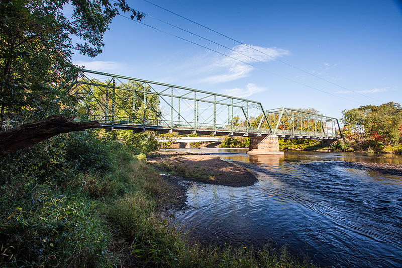
Nevius Street Raritan Bridge

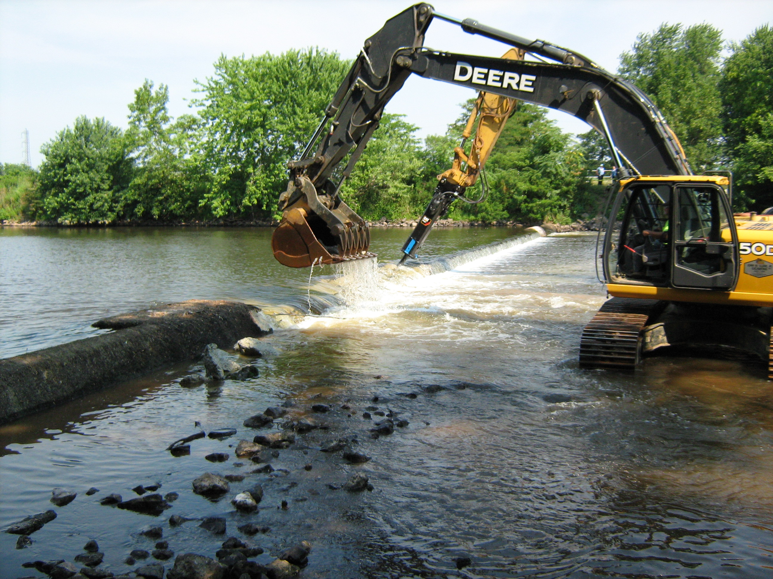
Department of Environmental Protection (DEP) Commissioner Bob Martin announced the start of the removal of a third dam from the Raritan River in Somerset County that will further open a 10-mile stretch of the middle and upper portions of the river to fish spawning and migration and also allow more recreational opportunities.

Removal of the Nevius Street Dam in Raritan Borough is the third and final dam elimination project on the Raritan River over the past three years that is financed by a landmark natural resource damages settlement secured by the DEP in 2010 with El Paso Corporation, which is now Kinder Morgan. This restoration project is being implemented as compensation to the public for harm to natural resources caused by past pollution at a refinery that was operated by or affiliated with El Paso.

In addition to the dam removals, the DEP received nearly $160,000 from Kinder Morgan for herring research on the Delaware River as part of the settlement.

“This is another example of the Christie Administration’s commitment to improved water quality and enhanced recreational opportunities in our state,’’ said Commissioner Martin. “This project makes excellent use of pollution settlement dollars to provide a major environmental improvement on the Raritan River. Also, residents and sportsmen in the region will enjoy the recreational benefits of this dam removal for generations to come.’’

“The significant ecological benefits of removing this dam are consistent with the efforts of Duke Farms to be a model of stewardship, and we are delighted to see the progress which has been made to enhance the Raritan as the true queen of New Jersey rivers,’’ added Michael Catania, Executive Director of Duke Farms, which owns the dam.

The Nevius Street Dam is being removed over the next two weeks as part of a watershed-wide effort to re-establish historically significant migratory fish passage, restore riverine habitat and the natural flow of the Raritan River, and enhance recreational uses.

Its elimination will add to habitat improvements realized from removal of the Calco Dam in Bridgewater in 2011 and the Robert Street Dam in Bridgewater and Hillsborough townships in 2012. Removal of the Nevius Street Dam should be completed within two weeks by Kinder Morgan’s contractor, River Logic, said Kinder Morgan project manager John Jengo.

Meanwhile, the DEP’s Office of Natural Resource Restoration continues to study additional dams in the Raritan River watershed and will evaluate and implement appropriate options for future enhanced fish passage and recreational opportunities.

The Nevius Street Dam is located just south of the Borough of Raritan at river mile 27.0 in Somerset County. It was constructed in 1901 by James Buchanan (Buck) Duke, the tobacco and hydropower industrialist, for aesthetic and recreational purposes as part of his development of Duke Farms, a 2,740-acre estate in Hillsborough Township.

The dam is constructed of mortared stone block over a concrete core, with a stair-step design on its downstream side. The dam length is approximately 195 feet.

A water intake structure was installed in the early 1960s on the north end of the dam and Duke Farms began utilizing this intake system for its primary water supply when their pumping withdrawals from the Raritan Water Power Canal were discontinued in the 1970s.

All three dam removals will open up 10 miles of migratory fish habitat along a stretch of the Raritan that twists through a highly diverse residential, commercial and agricultural portion of Somerset County that includes Bridgewater, Hillsborough, Bound Brook, Somerville and Manville. It also will open up about 17 miles of tributaries, including the Millstone River, to spawning. None of the dams were built for flood control:

Calco Dam, demolished in 2011, was located at river mile 20.9 and built by the Calco Chemical Co. in 1938 to disperse chemicals from its facility.
The Robert Street Dam, a 6 ½-foot-high sheet piling and concrete dam had been located at river mile 27.9 and was originally constructed prior to 1930 for purposes that are not known today.
The Nevius Street Dam, located at river mile 27.0, was constructed of rocks and mortar in 1901 for aesthetic purposes and later retrofitted to provide water to Duke Estate ponds.
Fish to benefit most from the removal of the dams are American shad, American eel, herring, and striped bass, which once migrated in prodigious numbers through the gravelly shallows of the Upper Raritan. Better water flow also will improve flushing of sediments, reduce nutrient loadings and improve conditions for tiny aquatic organisms that are critical to the food web in the river system.

"Somerset County is delighted to see this initiative of the Christie Administration and the DEP provide such tangible improvements to the Raritan River to help improve the quality of life for the citizens of Somerset County,” said Somerset County Freeholder Director Peter Palmer.

“The removal of the Nevius Street Dam will complement the borough's plans to make the Raritan River more accessible to our residents and a focal point for our own recreational and redevelopment efforts, added Raritan Mayor Jo-Ann Liptak.

Calco Dam in Bridgewater

The voluntary settlement with El Paso – now Kinder Morgan -- resolved Natural Resource Damage claims made by the DEP against the Houston-based company that stemmed from contamination at EPEC Polymers Inc. in Flemington, Hunterdon County; Nuodex Inc. in Woodbridge, Middlesex County; EPEC Polymers Inc. in Burlington City, Burlington County; and the Eagle Point Refinery in West Deptford, Gloucester County. Investigations and/or cleanups are under way at those sites.

The DEP uses funds secured from Natural Resource Damage settlements toward ecological restoration projects, typically in the same watershed or general area where resource damages occur.

For a copy of the settlement agreement, visit: http://www.nj.gov/dep/docs/elpaso-nrd-settlement.pdf

For more information on the DEP's Office of Natural Resource Restoration, visit: http://www.nj.gov/dep/nrr/

Monday, January 7, 2013

The Columbia Trail


Rails-to-Trails Conservancy is a non-profit organization whose mission it is to create a nationwide network of trails from former rail lines and connecting corridors to build healthier places for healthier people. One of NJ's rail lines that became a trail is the Columbia Trail in rural northwestern New Jersey. It was created from portions of the former Central Railroad of New Jersey High Bridge Branch.

The trail runs from High Bridge, in Hunterdon County, to Flanders, in Morris County. The trail is 16.2 miles (26.1 km).

The Columbia Trail is relatively flat and since it was a rail bed it consists mostly of fine crushed stone. It provides passive recreation to the surrounding communities through hiking, biking, and cross country skiing.

In Morris County, it parallels the South Branch of the Raritan River. At the northern terminus is Long Valley where the nearby Patriots' Path.

A notable portion of the Columbia Trail is the Ken Lockwood Gorge, between Califon and High Bridge (2½ miles north of High Bridge). The South Branch of the Raritan River parallels the trail through the gorge, and this is a scenic walk along this small river. The fast-flowing river is very popular for fly fishing. There is a 60-foot (18 m) trestle that carries the trail over the river in the gorge.

There is little evidence of the trail's railroad past, but a  small section of track is preserved in Califon and a small and rarely open museum dedicated to the rail line history is located in the preserved train station in the town center.

The original rail line accommodated passengers, but was known more for its shipments of iron ore from the mines in Morris County. A spectacular train wreck occurred on April 18, 1885 when Engine #112 (known as "The Columbia") and 45 cars plummeted off a 60' wooden trestle into the South Branch of the Raritan River. The wooden trestle was replaced by steel piers in 1930 and is now known as the Ken Lockwood Gorge Bridge. The last passenger excursion occurred in 1935 and the last freight train ran on April 1, 1976.

In the mid 1990's, the Columbia Gas Company of West Virginia constructed a gas line under the rail bed. The surface rights were then transferred to the Hunterdon County Division of Parks and Recreation for use as a recreational trail.

along the South Branch Raritan River through Ken Lockwood Gorge.

Parking and Trail Access
To reach the west, or High Bridge, end of the trail from I-78, take the exit for State Route 31 North. Turn right on West Main Street. After crossing under the railroad tracks, turn left. Trailhead parking is on the left just past the borough hall.

To reach the east, or Long Valley, end of the trail, from I-287, take the exit for US 206/202 North. Bear left to remain on US 206. Turn left onto SR 24. Follow SR 24 by turning right onto Schooleys Mountain Road. The trailhead parking lot is on your left.


MORE INFO
http://www.co.hunterdon.nj.us/depts/parks/ParkAreas/ColumbiaTrail/info.htm
http://www.traillink.com/trail/columbia-trail.aspx

Images: http://commons.wikimedia.org

Tuesday, August 9, 2011

The Everglades of Central Jersey

Image via appliedeco.com

Well, the marketing people weren't called in when they named Dismal Swamp in Central New Jersey. The Dismal Swamp Conservation Area is anything but dismal, in the same way that the "Pine Barrens" is not barren.

David Wheeler, Director of Operations for Edison Wetlands Association, (EWA) did several posts on the G.R. Dodge Foundation blog on protecting the Dismal Swamp.

Known as the “Everglades of Central Jersey,” the 1,240-acre Dismal Swamp Conservation Area is the largest natural area remaining in northern Middlesex County, spanning portions of Edison, Metuchen and South Plainfield. EWA is leading a number of coalitions to preserve, restore, promote, and transform this natural oasis from a long-overlooked area in one of New Jersey’s most overdeveloped regions into a nature sanctuary treasured by the public and immensely valuable to wildlife. EWA’s vision, leadership and collaboration resulted in the creation of the Dismal Swamp State Preservation Commission in 2009, with EWA’s Bob Spiegel continuing to strengthen this state oversight as Chair of the Commission.

The Dismal Swamp serves as a natural oasis holding United States Environmental Protection Agency Federal Priority Wetlands. The Dismal Swamp is home to over 180 species of birds, and two dozen species of mammals, amphibians and reptiles, as well as a dozen threatened and endangered species, such as the American bittern, bald eagle, and spotted turtle. The Dismal Swamp also provides natural flood control and wildlife habitat, while its forests produce oxygen, and its wetlands clean and purify water. 
EWA has worked since then to preserve many other key Dismal Swamp properties, partnering with groups like NY-NJ Baykeeper and New Jersey Audubon Society, and agencies like the Middlesex County Freeholders and the NY/NJ Port Authority to save over 800 acres in Edison and nearly 100 acres in South Plainfield from overdevelopment.

EWA is also working on a number of trails projects to expand opportunities for hiking, birding, and wildlife viewing in the area.
  • In 2011 the Middlesex Greenway just opened the newest leg of its trail connecting hikers and bicyclists from Perth Amboy, Woodbridge, and Edison with Metuchen’s portion of the Dismal Swamp. EWA continues to work with elected officials and the Edison Greenways Group to extend the greenway into the heart of South Plainfield’s Dismal Swamp.

David Wheeler is the author of Wild New Jersey. David also posted on the restoration of the Raritan River

Monday, January 31, 2011

Removal of Dams Will Open Up Fish Spawning

The Department of Environmental Protection has secured a landmark agreement that will open up a large stretch of the Raritan River for fish spawning as compensation to the public for harm to natural resources caused by past pollution at a refinery and three polymer plants that were operated by or affiliated with the El Paso Corp.

The removal of the dams, financed and carried out by El Paso, will open up a nearly 10-mile stretch of the middle and upper Raritan to fish migrations for the first time in more than a century, at the same time expanding recreational opportunities along the river.

"This unique and unprecedented settlement will make valuable habitat in the Raritan River available for fish spawning while improving overall environmental conditions in the river system," Commissioner Martin said. "In addition, dam removal will make it easier for kayakers, canoeists, and other lovers of the outdoors to enjoy a river system that has been undergoing a steady and impressive ecological comeback over the years."

The settlement resolves Natural Resource Damage claims by the DEP against the Houston-based company that stem from contamination at EPEC Polymers Inc in Flemington, Hunterdon County; Nuodex Inc. in Woodbridge, Middlesex County; EPEC Polymers Inc. in Burlington City, Burlington County; and the Eagle Point Refinery in West Deptford, Gloucester County. Investigations and/or cleanups are under way at those sites.

The settlement marks an important first step in what the DEP hopes will become an even broader effort to enhance fish passage or remove additional dams in the Raritan and its tributaries, including the Millstone River.

"This portion of the river was once an important spawning area for fish migrating from Raritan Bay," said Amy Cradic, Assistant Commissioner for Natural and Historic Resources. "This agreement is a major win for the environment by reopening these spawning areas and helping to restore balance to the estuary."

Natural Resource Restoration is the remedial action that returns the natural resources to pre-discharge conditions. It includes the rehabilitation of injured resources, replacement, or acquisition of natural resources and their services, which were lost or impaired. Restoration also includes compensation for the natural resource services lost from the beginning of the injury through to the full recovery of the resource.

Examples are:
  • GROUND WATER: non-point source pollution abatement projects, acquisition of land for aquifer recharge
  • WETLANDS and HABITAT: rehabilitation or creation of wetlands / habitat in the appropriate ratios to compensate for the functions and services lost
  • INJURED SPECIES: restoration of appropriate habitat and monitoring of success / research projects
  • LOST PUBLIC USE: enhanced public access, information and interpretive centers


Dam removal will open up 10 miles of migratory fish habitat along a stretch of the Raritan that twists through a highly diverse residential, commercial and agricultural portion of Somerset County that includes Bridgewater, Bound Brook, Somerville and Manville. It will also open up some 17 miles of tributaries to spawning. None of the dams were built for flood control.

The fish to benefit most from the removal of the dams are American shad, American eel, herring, and striped bass. These species once migrated in prodigious numbers through the gravelly shallows of the upper Raritan, most to spawn.

Striped bass and shad are important recreational species. Herring and eel are important food sources for other species in the ocean and estuaries, including game species such as striped bass, weakfish and bluefish.

Better water flow in the river will also improve flushing of sediments, reduce nutrient loadings and improve conditions for tiny aquatic organisms that are critical to the food web in any river system, Assistant Commissioner Cradic said.

The dams to be removed are:

Calco Dam, located at river mile 20.9 and built by the Calco Chemical Co. in 1938 to disperse chemicals from its facility. The dam is essentially a large concrete pipe spanning the river that today carries and disperses wastewater into the river for Somerset Raritan Valley Sewerage Authority. The authority has constructed a new outfall that will be operational shortly.

The Nevius Street Dam, located at river mile 27 and constructed of rocks and mortar in 1901 for aesthetic purposes and later retrofitted to provide water to ponds on the Duke estate. The DEP and El Paso are working on a plan to ensure the river continues to feed water to these ponds after the dam is removed.

The Robert Street Dam, a 6 ½-foot-high sheet piling and concrete dam located at river mile 27.9 and constructed prior to 1930 for purposes that are not known today.

The Island Farm wier, a dam located between the Calco and Nevius dams and constructed in the 1990s for the Elizabethtown Water Co. and the New Jersey Water Supply Authority, is not affected by the agreement with El Paso. A large fish ladder in operation at this dam is routinely monitored by the DEP's Division of Fish and Wildlife.

El Paso approached the DEP several years ago to cooperatively resolve its Natural Resource Damage liability. Natural Resource Damage claims seek to restore natural resources such as wetlands or groundwater and compensate the public for the amount of time the resources were harmed by pollution.

The DEP uses funds secured from Natural Resource Damage settlements toward ecological restoration projects, typically in the same watershed or general area where resource damages occur.

The Flemington and Woodbridge polymer facilities are located in the Raritan's watershed. The Eagle Point refinery, which El Paso once owned, and the Burlington County polymer facility are located in the Delaware River watershed. El Paso has agreed to provide the DEP $156,655 for a migratory fish study for the Delaware watershed.

The DEP has been working closely with stakeholders, including dam owners, environmental groups, property owners, local utilities, the U.S. Fish and Wildlife Service and the National Oceanic and Atmospheric Administration to make the Raritan River project a reality.

The DEP will continue working with El Paso as the company designs and implements the project. The company has already completed significant engineering studies and is expected to soon file for dam safety, land use and other DEP permits. The company is expected to launch the project this summer with the removal of the Calco Dam.

For a copy of the settlement agreement, visit: http://www.nj.gov/dep/docs/elpaso-nrd-settlement.pdf

For more information on the DEP's Office of Natural Resource Restoration, visit: http://www.nj.gov/dep/nrr

Friday, January 29, 2010

On the Banks of the Old Raritan


Albany Street Bridge over the Raritan in New Brunswick

Having spent four years at Rutgers College, I heard and sang the alma mater plenty of times at events. "On the Banks of Old Raritan"  (listen to it too)was more than a song in those years, because I spent a lot of time on the actual banks of the river and staring at it from my river dorm window (and flying some masterfully made paper planes over it to Johnson Park).

And so I settled down,
In that noisy college town,
On the banks of the old Raritan.


The River Dorms


The Raritan River is New Jersey's largest river that is entirely contained in the state.

Its watershed drains much of the mountainous area of the central part of the state, emptying into the Raritan Bay on the Atlantic Ocean. There are 1,100 square-miles of rivulets and streams that spill into the Raritan. The river's source is Budd Lake in the more rural northwestern part of the state. Its path through the state takes it through 100 municipalities and seven counties to an industrial end in Middlesex County.

The Raritan River forms at the confluence of the North and South Branches just west of Somerville. It flows 16 miles before slowing in tidewater at New Brunswick. Its estuary extends 14 miles more until the Raritan Bay at South Amboy.

So, naturally, there would be some further Raritan and Rutgers connections. The Sustainable Raritan River Initiative is one where Rutgers and the over thirty partner organizations and businesses are collaborating to restore and revitalize the Raritan River.


The threats facing the Raritan include over 150 significantly contaminated sites, the legacy of its industrial heritage, and stormwater runoff that erodes riverbanks and brings trash and pollutants into the waterway, the legacy of antiquated infrastructure in a highly urbanized region.

The lower watershed, cited as 14th among US rivers polluted by direct and sewer discharges of toxic chemicals (from 1990-1994), has been heavily impacted by intense industrial and storm runoff pollution and heavy flooding due to extensive urban impervious surfaces and climate change.

But the Raritan River basin also has spectacular natural areas, wildlife habitat, trails and recreational boating areas. It also has scenic waterfront redevelopment opportunities that create the potential for long-term balance and sustainability for the River and the towns that border it.


Some History
The Raritan River was an important water transportation route for the Native Americans. The “Raritan” was an Algonquin word meaning “stream overflows.” The Raritan people were also an Algonquin tribe.

In colonial days, early industry around developed along the Raritan around New Brunswick. During the Revolutionary War, the river provided a means for troop conveyance.

However, before the American Revolution, early Dutch settlers built grist mills on the Raritan, called the “Forked River” by Native Americans.

In the 1830s the Raritan-Delaware Canal provided a waterway connecting Philadelphia and Pennsylvania’s coal fields to New York.

Marshall 1836 Antique Map of Raritan River to Elk Head - $259


The Lower Raritan Watershed’s environmental health has rebounded over the past decade, but there is a long way to go. Bald eagles, peregrine falcons, and osprey again soar the Raritan skies, and a thriving fish population has helped seals, otters, and marine life recover here.

The Edison Wetlands Association (EWA) Raritan River Project has fought since 1989 for the cleanup and restoration of the hazardous waste sites posing the greatest threats to human health and environment.

The Lower Raritan Watershed has a disproportionate amount of the NJ 25,000 toxic waste sites draining into its watershed. Most of these are not remediated to levels that are protective of human health or the environment. Federal and State regulatory agencies responsible for cleaning up these sites have abdicated their responsibilities and the pollution remains unchecked. Over-development threatens the remaining natural areas along the Raritan and her tributaries.

To end on a positive note, the relatively pristine Upper Raritan is a habitat for endangered ancient wild brook trout. It is challenged by an excessive deer population that is seriously reducing vegetative and forest renewal and by the need to preserve its farms and open space.

“Ode to the Raritan, Queen of Rivers”
by John Davis, 1806

All thy wat’ry face
Reflected with a purer grace
Thy many turnings through the trees,
Thy bitter journey to the seas,
Thou Queen of Rivers, Raritan!


More...

Friday, May 29, 2009

Cleaning Up the Raritan River

The Raritan River is New Jersey's largest river that is entirely contained in the state. Still, it does not get the attention of the Hudson or the Passaic rivers when it comes to pollution and cleanup.


There are 1,100 square-miles of rivulets and streams that spill into the Raritan. The river's source is Budd Lake in the more rural northwestern part of the state. Its path through the state takes it through 100 municipalities and seven counties to an industrial end in Middlesex County.

The Star Ledger reported on a recent symposium dedicated to the Raritan that plans to address on an annual basis the toxic cleanup and needed public access points for the Raritan River.

The Edison Wetlands Association, co-sponsored the event along with Rutgers University's Edward J. Bloustein School of Planning and Public Policy.

They discussed the fate of this waterway which was nicknamed "the Queen of Rivers" two centuries ago by poet John Davis, but whose estuary in Middlesex County goes today by the name "Valley of the Dumps." It was a sad turn for the river that gave refuge to General GeorgeWashington during the Revolutionary War to make the list as the country's 14th most-polluted river in the country in 1994.


Executive director of the Edison Wetlands Association,
Robert Spiegel, examines a dead turtle found
along a polluted stretch of the Raritan River in Edison.

The 12 miles of the lower Raritan River (New Brunswick and south) is the worst section. This area has ten Superfund sites either on the river or in places that drain into it.

The river also touches on 16 species on the state endangered list, such as bald eagles, rare butterflies and a type of mussel known as tidewater mucket.

Monday, May 11, 2009

Rivers Can Be Endangered Too


Here's a list we don't want New Jersey to make it onto - the ten most endangered rivers in the U.S. as selected by AmericanRivers.org

A much better list is that of green infrastructure projects involving our waterways. There are a number of ready-to-go projects in New Jersey. These projects would be worth over $53 million in jobs and materials, but, more importantly to this blog, they would also improve clean water and boost natural flood protection.
“Clean water is our nation’s most vital resource, but our water infrastructure is outdated and crumbling, unable to cope with our drinking water, wastewater, and flood protection needs,” said Betsy Otto, vice president of strategic partnerships for American Rivers. “The good news is, investments in green solutions to these water infrastructure problems will create jobs, save money, and protect public health and safety.”
A wetland restoration project in Oxford, NJ could restore 225 acres of failing agricultural lands and a failing private levee along Furnace Brook to forested and floodplain wetlands. Nearly one mile of levees would be removed, ditching would be backfilled, and the land would be planted again to forested and marsh wetland vegetation. This project would restore natural flood protection and reduce downstream flood damage, improve wildlife habitat and expand an adjacent state wildlife area.

In Trenton, the Assunpink Creek restoration project would remove a culvert and improve the health of this Delaware River tributary. The effort would also include the construction of a multiple-use trail for public recreation. 

The Lower Millstone River Fish Passage Project is another project. The Millstone River, a tributary to the Raritan River, is near the townships of Franklin and Hillsborough, NJ. The Stony Brook-Millstone Watershed Association will conduct a study to examine the feasibility of restoring American shad and other fish in the lower Millstone River in central New Jersey. Among other potential restoration strategies, the project will explore the possibility of removing two dams on the lower Millstone River which would open an additional 14.1 miles of the river to fish. The study will assess the potential positive and negative effects of dam removal as well as other potential methods for providing fish passage on the river.