Showing posts with label Burlington County. Show all posts

Friday, August 27, 2021

Epizootic Hemorrhagic Disease Found in Burlington County

The NJ Division of Fish and Wildlife has confirmed Epizootic Hemorrhagic Disease (EHD) in a deer recently sampled in Burlington County. EHD is not a threat to public health, but we advise against consuming meat from any game animal that appears ill.

EHD outbreaks typically begin in late summer and disease transmission ends when the first hard frost kills the midges that carry the disease.

The Division is asking the public to be alert for deer that may be affected by EHD and to report any suspected cases. Symptoms include difficulty standing, drooling, lethargy, respiratory distress, foam from the mouth or nose, and swelling of the face, tongue, and neck. Sick or dead deer are often seen in or near water.

Reports can be made to:

Wednesday, September 5, 2018

Saving One of NJ's Last Wild Populations

That title probably suggest to you some wild creature roaming the Garden State. But it refers to an NJDEP press release about trying to save New Jersey’s last remaining wild population of a plant.

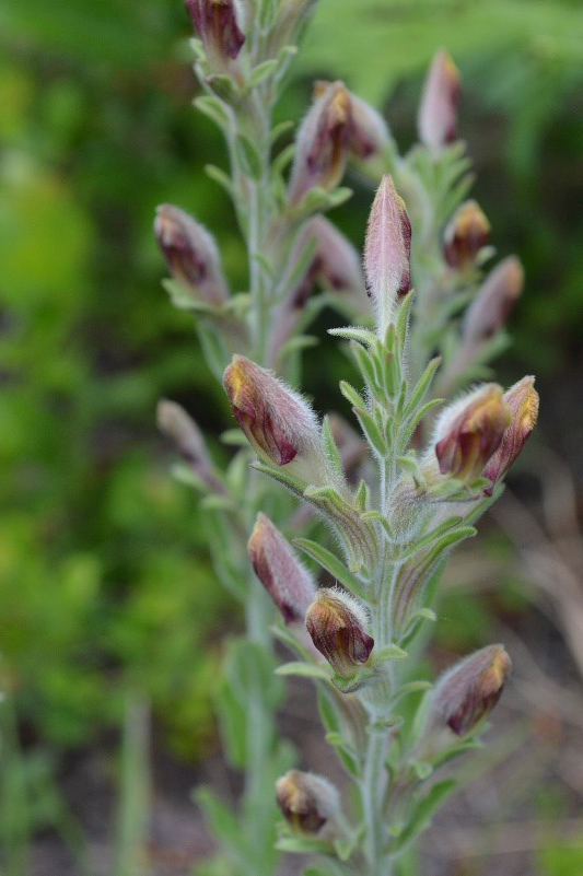
The plant is American chaffseed, a flowering perennial herb with highly specialized habitat needs. The species’ last stronghold is in a state forest in the Pinelands of Burlington County.


American chaffseed (Schwalbea americana)

The project is being overseen by the DEP’s Office of Natural Lands Management. This year, the total number of American chaffseed flowers at the Burlington County site is double that of recent years, with the number of stems up 65 percent from last year. All of this points to an increase in the overall number of plants next year.

Resembling a snapdragon, American chaffseed needs open meadows with sandy and acidic soil as well as nearby wetlands. Seeds of American chaffseed also require contact with the roots of a host plant to germinate. Known host plants in New Jersey include Maryland golden aster, inkberry and dwarf huckleberry.

The American chaffseed is listed as endangered by the state as well as the federal government. The biggest threats to American chaffseed across its range include development, mowing and suppression of wildfires that are needed to remove competing understory vegetation.

The species was once found at 18 locations in New Jersey, all in or near the Pinelands. At one time, the species was found in 16 states from Massachusetts to Louisiana, and as far west as Kentucky and Tennessee. Today its range has diminished to spotty populations in eight states along the Atlantic and Gulf of Mexico coasts.

Wednesday, August 9, 2017

Endangered New Jersey History

Yes, historic places are often on their own endangered lists around the world and New Jersey is no exception.

One list is at the www.thehistorygirl.com website (They are also on Twitter) and on Preservation New Jersey's site you'll find their annual list of the state's 10 most endangered historic places.

The places vary in age and usage. For example, there is the Colemantown Meeting House and Jacob's Chapel, in Mount Laurel (Burlington County). This circa-1865 chapel and meeting house along with an even older cemetery are all that remain of the 19th-century African-American community of Colemantown.

The meeting house was made even more endangered than it had been after Superstorm Sandy flooded it and made the building unusable. With an estimated $1.3 million needed for repair, restoration and site improvements, the price tag is well beyond the means of the congregation.

Jacob's Chapel  (NPS)
The Jacob's Chapel A.M.E Church property, which includes the Colemantown Meeting House, the Chapel and cemetery mark the emergence, growth, and decline of Colemantown. This antebellum African American settlement established in 1828 flourished into the 20th century and was an important event within Burlington County history.

The Colemantown Meeting House (moved to its current location in 1965) served as both the first worship sanctuary in Colemantown and as a schoolhouse for the hamlet's children and is one of the oldest all-black schoolhouses still extant in New Jersey.

The cemetery was inaugurated about 1849. In the immediate aftermath of the Civil War, the growing congregation, then led by Jacob Mitchell, an A.M.E minister known for his success in helping other black churches build their own sanctuaries, led the effort to build the present Jacob's Chapel in 1866-67.

Founder's Fountain in better days - Photo CC 2.5 
Not all endangered NJ history is a building or place. An example is Founders Fountain in Monmouth County's Founder's Park. The park was established on the site of the first Camp Meeting in Ocean Grove, off Pilgrim's Pathway.

This elaborate cast iron fountain was the centerpiece of the park when it was placed there in 1907 as a memorial. Vandals clogged it in 1977, but it remains partially intact, but in severe disrepair. Many of the original molds are available for the fountain’s restoration, but the expensive cost is beyond the means of the historical society that owns it.


You might not think of most school buildings as being historic, but Camden High School is a century-old Collegiate Gothic-style building that is also known as the "Castle on the Hill."

Camden High School's Class of 2017 is the last graduating class of "The Castle on the Hill" as the school is slated to be demolished this year to make room for a new $133 million state-of-the-art high school.

The chances are very slim that the building will be saved.

Friday, October 14, 2016

Batsto Village Country Living Fair October 16


Batsto Village, a beautiful historic village within Wharton State Forest, will host the annual Country Living Fair on October 16, 2016, as part of the Village’s 250th anniversary celebrations. The 31st annual Country Living Fair will take place on Sunday, October 16, from 10 a.m. to 4 p.m. Admission is free.


Batsto Village is located on Rt. 542 in Washington Township in Burlington County. The Village, which is listed on both the New Jersey and National Register of Historic Places, includes more than 40 sites and structures, including the Batsto Mansion, a sawmill, a 19th-century ore boat, a charcoal kiln, ice and milk houses, a carriage house and stable, a blacksmith and wheelwright shop, a gristmill and a general store. The Batsto Post Office, established in 1852, still processes mail with a postmark having no zip code.

The popular fair will provide visitors to the South Jersey historical area with many opportunities to experience the joys of country life from when Batsto was founded in 1766 and right up to the current day. The fair will offer crafts, exhibits, music, old-time engines and cars, food, antiques, pony rides, farm equipment, chain-saw art, quilting, and more authentic South Jersey country attractions.


About the Country Living Fair batstovillage.org/country-living-fair.htm.

Directions to the village batstovillage.org/road-directions.htm

Learn more about Batsto Village batstovillage.org

More about Wharton Stae Forest state.nj.us/dep/parksandforests/parks/wharton.html


Wednesday, May 11, 2016

Water Trails in New Jersey


If you're one of the people who paddles along a New Jersey lake or river, you're probably not all that different from the oldest inhabitants of this area. Long before roads,  Indians and then settlers to this area traveled on our waterways across the area. These water trails became the places for towns and eventually paralleled the paths, roads and highways.

When most people think about "trails" they imagine paths through the woods. But some of those paths through wilderness are liquid and the mapping of "water trails" is happening more and more.

This mapping and designation can help protect natural areas as well as provide places for kayaking, canoeing and stand-up paddling.

In New Jersey, we have designated water trails including ones on the Delaware River, the South Branch of the Raritan River, the Egg Harbor River, the Maurice River and the Hackensack River.

But we don't have any water trails that are designated such by the National Park Service.


There are two in New York, but none in NJ or Pennsylvania. The Bronx River Blueway which passes directly through the New York Botanical gardens, the Bronx River Forest, cityscapes, and the Bronx Zoo is one.

The other NY water trail is the Hudson River Greenway Water Trail which is designed for day-users as well as long-distance paddlers. It includes 94 designated access sites, wildlife marshes, islands, historic sites, cities, downtowns, and hiking trails.

Some paddling enthusiasts in Burlington County are trying to get the Rancocas Creek to become New Jersey's first nationally-designated water trail. Certainly our Jersey waterways must have more than a few places suitable for the designation!

The National Park Service loks for sites with boat landings in protected areas, existing parkland and multi-use recreation areas along the creek, and also educational and cultural heritage opportunities along the way on the shore or nearby.


The Rancocas Creek watershed is one of the state's largest, covering 360 square miles.

The North Branch flows about 30 miles, from its headwaters in the pitch pine lowlands of the Pine Barrens in western Ocean County to the main stem in Hainesport.

The Burlington County park system maintains a 14-mile canoe trail with access points in Pemberton, historic Smithville and Mount Holly.


The South Branch of the Rancocas flows for about 22 miles to the main stem, and the Southwest Branch is about 18 miles long. The three branches join the creek's main stem, a wide, tidal waterway used by motorized boats as well as canoes and kayaks.


For more about the efforts to get the Rancocas Creek designated, go to www.rcnwt.com

Tuesday, March 26, 2013

Hike the Batona Trail

Step Into Nature header 

Hike the Batona Trail
Saturday, April 6
 9 a.m. to 3 p.m.
Chatsworth, Burlington County
  
Franklin Parker Preserve trail
Franklin Parker Preserve photo by Mike Pavarini
Hike the newly-relocated section of the Batona Trail with Chris Jage, New Jersey Conservation Foundation's assistant director for South Jersey.

Hikers will explore new areas of the 9,400-acre Franklin Parker Preserve in the Pine Barrens. The hike is 8 miles long and briskly paced for the avid hiker.

The cost is $5 per person, and advance registration is required. Space is limited.

To register online, click here. 

For more information, contact Dolce Vieira at dolce@njconservation.org or 908-234-1225, ext. 126.

This event is part of New Jersey Conservation Foundation's Step Into Nature series of walks, talks and fun outdoor activities. For a full schedule of Step Into Nature programs, click here >>

Friday, June 29, 2012

Blueberry Picking in the Pine Barrens

The Franklin Parker Preserve, New Jersey Conservation Foundation's largest preserve, is known mostly for its history of cranberry cultivation, but it also includes some large, previously cultivated blueberry fields. Many of these areas continue to produce big, delicious blueberries.

Come out for an "all you can pick" experience on Saturday, July 14, from 9 - 11 a.m. at the Franklin Parker Preserve in Chatsworth, Burlington County.

Participants will carpool and caravan from the meeting location to the blueberry fields. Bring your own blueberry containers, as well as plenty of water. Wear long pants, a long-sleeved shirt and a hat. Trip leader will be Russell Juelg, Land Steward and Pine Barrens Educator.

The cost is $5 per adult, free for children. Reservations will be confirmed and directions sent when the fee and waiver are received.

Register online at http://donate.njconservation.org/Registration. If you have questions or need more information, contact Laura (laura@njconservation.org; 908-234-1225).

More Step Into Nature event listings for other walks, talks and fun activities are at http://www.njconservation.org/njcfevents.cfm

Monday, January 31, 2011

Removal of Dams Will Open Up Fish Spawning

The Department of Environmental Protection has secured a landmark agreement that will open up a large stretch of the Raritan River for fish spawning as compensation to the public for harm to natural resources caused by past pollution at a refinery and three polymer plants that were operated by or affiliated with the El Paso Corp.

The removal of the dams, financed and carried out by El Paso, will open up a nearly 10-mile stretch of the middle and upper Raritan to fish migrations for the first time in more than a century, at the same time expanding recreational opportunities along the river.

"This unique and unprecedented settlement will make valuable habitat in the Raritan River available for fish spawning while improving overall environmental conditions in the river system," Commissioner Martin said. "In addition, dam removal will make it easier for kayakers, canoeists, and other lovers of the outdoors to enjoy a river system that has been undergoing a steady and impressive ecological comeback over the years."

The settlement resolves Natural Resource Damage claims by the DEP against the Houston-based company that stem from contamination at EPEC Polymers Inc in Flemington, Hunterdon County; Nuodex Inc. in Woodbridge, Middlesex County; EPEC Polymers Inc. in Burlington City, Burlington County; and the Eagle Point Refinery in West Deptford, Gloucester County. Investigations and/or cleanups are under way at those sites.

The settlement marks an important first step in what the DEP hopes will become an even broader effort to enhance fish passage or remove additional dams in the Raritan and its tributaries, including the Millstone River.

"This portion of the river was once an important spawning area for fish migrating from Raritan Bay," said Amy Cradic, Assistant Commissioner for Natural and Historic Resources. "This agreement is a major win for the environment by reopening these spawning areas and helping to restore balance to the estuary."

Natural Resource Restoration is the remedial action that returns the natural resources to pre-discharge conditions. It includes the rehabilitation of injured resources, replacement, or acquisition of natural resources and their services, which were lost or impaired. Restoration also includes compensation for the natural resource services lost from the beginning of the injury through to the full recovery of the resource.

Examples are:
  • GROUND WATER: non-point source pollution abatement projects, acquisition of land for aquifer recharge
  • WETLANDS and HABITAT: rehabilitation or creation of wetlands / habitat in the appropriate ratios to compensate for the functions and services lost
  • INJURED SPECIES: restoration of appropriate habitat and monitoring of success / research projects
  • LOST PUBLIC USE: enhanced public access, information and interpretive centers


Dam removal will open up 10 miles of migratory fish habitat along a stretch of the Raritan that twists through a highly diverse residential, commercial and agricultural portion of Somerset County that includes Bridgewater, Bound Brook, Somerville and Manville. It will also open up some 17 miles of tributaries to spawning. None of the dams were built for flood control.

The fish to benefit most from the removal of the dams are American shad, American eel, herring, and striped bass. These species once migrated in prodigious numbers through the gravelly shallows of the upper Raritan, most to spawn.

Striped bass and shad are important recreational species. Herring and eel are important food sources for other species in the ocean and estuaries, including game species such as striped bass, weakfish and bluefish.

Better water flow in the river will also improve flushing of sediments, reduce nutrient loadings and improve conditions for tiny aquatic organisms that are critical to the food web in any river system, Assistant Commissioner Cradic said.

The dams to be removed are:

Calco Dam, located at river mile 20.9 and built by the Calco Chemical Co. in 1938 to disperse chemicals from its facility. The dam is essentially a large concrete pipe spanning the river that today carries and disperses wastewater into the river for Somerset Raritan Valley Sewerage Authority. The authority has constructed a new outfall that will be operational shortly.

The Nevius Street Dam, located at river mile 27 and constructed of rocks and mortar in 1901 for aesthetic purposes and later retrofitted to provide water to ponds on the Duke estate. The DEP and El Paso are working on a plan to ensure the river continues to feed water to these ponds after the dam is removed.

The Robert Street Dam, a 6 ½-foot-high sheet piling and concrete dam located at river mile 27.9 and constructed prior to 1930 for purposes that are not known today.

The Island Farm wier, a dam located between the Calco and Nevius dams and constructed in the 1990s for the Elizabethtown Water Co. and the New Jersey Water Supply Authority, is not affected by the agreement with El Paso. A large fish ladder in operation at this dam is routinely monitored by the DEP's Division of Fish and Wildlife.

El Paso approached the DEP several years ago to cooperatively resolve its Natural Resource Damage liability. Natural Resource Damage claims seek to restore natural resources such as wetlands or groundwater and compensate the public for the amount of time the resources were harmed by pollution.

The DEP uses funds secured from Natural Resource Damage settlements toward ecological restoration projects, typically in the same watershed or general area where resource damages occur.

The Flemington and Woodbridge polymer facilities are located in the Raritan's watershed. The Eagle Point refinery, which El Paso once owned, and the Burlington County polymer facility are located in the Delaware River watershed. El Paso has agreed to provide the DEP $156,655 for a migratory fish study for the Delaware watershed.

The DEP has been working closely with stakeholders, including dam owners, environmental groups, property owners, local utilities, the U.S. Fish and Wildlife Service and the National Oceanic and Atmospheric Administration to make the Raritan River project a reality.

The DEP will continue working with El Paso as the company designs and implements the project. The company has already completed significant engineering studies and is expected to soon file for dam safety, land use and other DEP permits. The company is expected to launch the project this summer with the removal of the Calco Dam.

For a copy of the settlement agreement, visit: http://www.nj.gov/dep/docs/elpaso-nrd-settlement.pdf

For more information on the DEP's Office of Natural Resource Restoration, visit: http://www.nj.gov/dep/nrr

Friday, March 26, 2010

D&R Greenway


D&R Greenway Land Trust is central New Jersey's non-profit land preservation organization, founded in 1989 through the collaboration and vision of four organizations: the Stony Brook - Millstone Watershed Association, Friends of Princeton Open Space, Regional Planning Partnership, and the Delaware & Raritan Canal Commission.

They were originally named the Delaware & Raritan Greenway, but they changed their name in 2004 to better reflect their preservation work as a Land Trust, and because their work expanded beyond the focus on the Delaware & Raritan Canal.

I actually heard about them because of a poetry event they offered recently called "Living Among Giants, Seeing the Forest for the Trees." It's one of a number of public programs they offer at at the Johnson Education Center.

They cover a lot of ground. Their operating region consists of over 1,500 square miles, encompassing portions of the Delaware, Raritan and Millstone River watersheds and the Delaware & Raritan Canal. This includes Mercer, Hunterdon, Somerset, Middlesex, Burlington and Monmouth counties.

Recently, they have also worked at preserving preservation of farmlands in Salem County in the area of Mannington Meadows.

Since 1989, D&R Greenway Land Trust has preserved 223 properties. The total acreage preserved as of February 1, 2010 is 14,320.69 acres valued at $316,177,653.

Friday, October 23, 2009

Greenwood Forest and Pasadena Wildlife Management Area

In our continuing series on Wildlife Management Areas and Wildlife Viewing Areas in NJ, today we look at The Greenwood Forest/Pasadena Wildlife Management Area.

This WMA is in Burlington and Ocean Counties in Lacey, Barnegat, Manchester, Berkeley & Woodland Townships. At 95,923 acres it is the largest tract of land preserved by the New Jersey Division of Fish and Wildlife's Bureau of Land Management.

Together with Brendan T. Byrne State Forest, this area constitutes most of the Western Pinelands, the smallest of four conservation zones identified in the Pinelands by NJ Wildlife Action Plan.

This habitat is made up of mixed pine and riparian forests with patches of fields and shrub-scrub. Most of the area is upland pine-oak and scrub-shrub forests with the remaining area being upland habitats including fields.

The lowlands contain pitch-pine forest and Atlantic white cedar bogs.

The headwaters of Cedar Creek are also found here and it connects Greenwood Forest / Pasadena WMA to Lebanon State Forest.

This forest habitat supports breeding species including an estimated 100 Eastern Towhees, 100 Pine Warblers and 60 Prairie Warblers. Barred Owls, favoring swamps and deep forests, particularly those bordering lakes, streams or marshes, are permanent residents in this IBA. Sporadic populations of Red-headed Woodpeckers also inhabit the site’s low-density forest stands.

Some species found here include: the state-threatened Barred Owl, Blue-winged Warbler, Brown Thrasher, Eastern Towhee, Eastern Wood-Pewee, Field Sparrow, Northern Bobwhite, Pine Warbler, Prairie Warbler, Whip-poor-will, Baltimore Oriole, Black-and-white Warbler, Black-billed Cuckoo, Blue Jay, Common Grackle, Eastern Wood-Pewee, Gray Catbird, Tufted Titmouse, and Yellow-billed Cuckoo. See http://www.njaudubon.org for more information.

Northern Pine Snake - NJDEP photo

Currently, the Endangered and Nongame Species Program is working with the Division's Bureau of Land Management to enhance pine snake habitat in a portion of Greenwood Forest Wildlife Management Area.

The primary threats to this site include over-abundant deer and loss of natural ecological forces such as fire and disturbance.

Approximately 1000 acres of the Greenwood Forest/Pasadena WMA are managed as quail habitat and offers hunting and wildlife viewing opportunities.

There are also several hiking and wildlife-watching opportunities throughout the site.

More information: (PDF documents)