Showing posts with label Passaic County. Show all posts

Monday, August 4, 2025

The New Jersey Highlands

The Highlands of New Jersey is one of those areas that people from other parts of the country just don't associate with NJ. (The Pinelands is another area like that.) The forested ridges, rocky cliffs, and the streams, lakes, ponds, and reservoirs for fishing and recreation are all there. 

The Highlands covers 840,000 acres and includes 188 municipalities. There are 7 Highlands counties – Bergen, Passaic, Morris, Sussex, Warren, Hunterdon, and Somerset – and all contain a diversity of forests, wetlands and grasslands. That habitat diversity is also home to threatened and endangered wildlife.

There are 72 New Jersey-listed endangered, threatened, and rare animal species, including mammals, birds, amphibians, reptiles, butterflies, dragonflies, damselflies, and mussels, and two species (the Indiana bat and bog turtle) are Federally-listed. There are also 137 endangered, imperiled, and rare plant species.

The Highlands also contains historic structures and archaeological heritage sites that need protection.

Hikers can find miles of trails, including both the Appalachian Trail and the Highlands Millennium Trail.

For over half of New Jersey’s residents (4 million+), the Highlands is a critical area for their drinking water. The NJ Highlands Water Protection and Planning Act was passed in 2004, dividing the 840,000-acre region into a “Preservation Area” with strict NJDEP regulations and mandatory Regional Master Plan conformance, and a “Planning Area” with voluntary Plan compliance.

As is often the case in NJ, suburban sprawl is the greatest threat to the Highlands’ drinking water supply, and to the forests, farms, wildlife habitat, and historic, recreational and scenic resources.

There are several areas in NJ that are a focus for Highlands Coalition.

The Wyanokie and Farny Highlands (Passaic and Bergen) contain unprotected lands in nearby Wanaque and Split Rock reservoirs that would connect existing State and county parks and forests in these two heavily utilized recreational areas. This focal area was ranked highly due to its value for water resources and recreation, and secondarily for biodiversity and forest land.

The Pequannock Watershed (Morris, Passaic, and Sussex) serves as the core of the northern New Jersey Highlands and serves as a major hub connecting existing open space areas. This focal area was ranked highly due to its multiple values for water resources, forest land, biodiversity, and recreation.

The wooded ridges of Sparta Mountain/Lubber’s Run (Morris and Sussex) provide an important greenway corridor connecting Mahlon Dickerson Reservation in the north and Allamuchy Mountain State Park in the south. Major gaps in conservation protection include the nearby areas of Mase Mountain. This focal area was ranked highly due to its value for productive forest land, biodiversity, and recreation.

Upper Pohatcong/Pequest area (Warren) also contains forested ridges and wetlands centered around the Pequest Wildlife Management Area, which serve as an important groundwater recharge, wildlife habitat, and outdoor recreation area. This focal area was ranked highly due to its value for water resources and recreation and secondarily for its productive forest and farmland.

Scott Mountain/Musconetcong Ridge in Warren and Hunterdon counties and the neighboring productive farmland of the Delaware, Pohatcong, and Musconetcong valleys form a large contiguous area of high-quality rural landscape. This focal area was ranked highly due to its value for biodiversity and productive farmland, and secondarily for forest land and recreation.

MORE

Wednesday, July 23, 2025

NY & NJ Trails

You can enjoy some excellent hiking trails and hikes within or just a day-trip away from New Jersey. People from other parts of the country (and, unfortunately, a lot of people in NJ) find that surprising.

Since 1920, the New York-New Jersey Trail Conference has partnered with government and private landowners to create, protect, and maintain a network of 1,700 miles of hiking trails in the New York-New Jersey metropolitan region.

The Trail Conference is a volunteer driven not-for-profit organization with a membership of 10,000 individuals and more than 100 clubs.

Want to take an easier hike and see waterfalls? Try They have a nice online search tool for finding hikes by difficulty (Easy, Moderate or Strenuous) or by Views and Features like waterfalls.

Hedden County Park in Morris County, NJ an easy 3.2 miles hike that includes a waterfall - or - try Falling Waters and Grand Loop Trails at Schooley's Mountain County Park (also Morris County) which is just 2.5 easy miles with a waterfall view.

Want more of a workout and also a hike you can take public transportation to instead of your car?

Horse Pond Mountain Loop at the Long Pond Ironworks State Park is 6 moderate to strenuous miles. Crossing a causeway over the Monksville Reservoir, you'll pass the historic buildings of the Long Pond Ironworks on your way.

The Trail Conference can even provide the best map for the hike.

Monksville Reservoir from Horse Pond Mountain

Thursday, December 1, 2022

Fishers and Minks

Endangered NJ gets lots of reports of wildlife sightings. Unfortunately, the majority are not accompanied by photos, videos, or any kind of physical evidence (such as tracks), so we can't always confirm the sighting.

Jamie in Lincoln Park sent us the backyard trail camera photo below of a fisher taken this month. The area borders the Great Piece Meadows Preserve off of RT 80. 

Fisher 

An earlier email was another possible fisher sighting about a half mile from Bearfort fire tower in West Milford near Cedar Pond, but the photos were too unclear to verify. 

Fishers (Martes pennanti) are the rarest of our state's water-loving mammals. They have made a comeback in northwestern New Jersey. Fishers were extirpated from New Jersey in the 1800s as their range in Sussex and Warren counties was taken over by farmland early in the country's history, forcing the animals to deeper woods. 

They are fierce carnivores and will hunt squirrels, rabbits, chipmunks, mice, raccoons, shrews and even porcupines. 

Fisher    Photo: Mass Audubon

"Also referred to as the fisher cat and Appalachian black cat, this animal looks like fluffy cat meets fox, with a wolverine-like disposition. However, it is neither a feline nor does it catch fish. The fisher is a member of the Mustelidae family, which includes otters, badgers, martens, ferrets, minks, wolverines and more."    source

Minks are also part of that family and are native New Jersey mammals found in and around freshwater. They and other aquatic and semi-aquatic mammals – including beavers, otters, weasels, ermine, fishers and muskrats – live in our state but are not easy to spot.

I recently saw a post on Instagram from the Verona Park Conservancy of their resident mink. You don't always have to go into the deep woods to find wildlife.


You might be surprised to learn that the American mink is actually a very common species found along watercourses, ponds, lakes and swamps throughout New Jersey. However, they are primarily nocturnal and quite solitary animals, so people rarely encounter them.

Mink (Mustela vision) were well known for their beautiful, soft fur which was prized by trappers and for a long time was used for women's fur coats and clothing. Thankfully, that practice became unpopular as awareness of wildlife becoming threatened and endangered became better known. 

The American mink has a lanky body, long tail, short legs, and partially webbed toes, which make them excellent swimmers. They are quite territorial and feed on crayfish, frogs, fish, mice, reptiles, earthworms, and waterfowl. They aren't a threat to humans but like their skunk cousins, they will defend themselves by spraying a foul-smelling liquid.

More of our posts about:
fishers
minks

Sunday, December 16, 2018

Holiday Activities at New Jersey State Parks

Historic Christmases in New Jersey ranging from the American Revolution to the Victorian era and modern day are among the highlights of annual holiday activities planned this month at state parks, according to a NJDEP press release.

“Christmas is a special time in New Jersey, with many activities for the public to recall our important place in history and to celebrate the beauty and magic of the season,” Parks and Forestry Director Olivia Glenn said. “There is something for everyone at many of our parks, from seeing the stately Ringwood Manor decorated as it would have been during its heyday, to watching busy elves in Santa’s workshop, to the always popular Delaware River crossing on Christmas. These activities are a great way to enjoy the holiday spirit.”


Ringwood Manor
Ringwood Manor at Ringwood State Park in Passaic County is hosting the 43rd Annual Victorian Christmas, showcasing holiday décor from the 19th century, while Washington Crossing State Park will host the annual Christmas Day re-enactment of Gen. George Washington and his troops crossing the Delaware River. Other activities include a reading of the Charles Dickens classic A Christmas Carol at Waterloo Village in Sussex County and history-themed fun at The Historic Village at Allaire in Allaire State Park in Monmouth County.

The 19th century Ringwood Manor is listed on the National Register of Historic Places. The stunning house that was home to well-known ironmasters in the 19th and 20th centuries sits on a low hill that overlooks a rustic landscape, making it a beautiful location to visit during the holidays and winter.

From 1 p.m. to 3 p.m. on Dec. 16, Santa Claus and his elves will be busy in their workshop at Ringwood State Park’s Hermitage Museum Visitor Center to greet children and their families.

Children can spend time at holiday craft tables, surrounded by vintage toys, trains, Christmas trees, holiday decorations and music. Refreshments will be provided. Admission is $6 for adults, $4 for children ages 6-12, and free for children age 5 and younger. Santa’s Workshop is sponsored by Friends of the Hermitage.

Remaining dates to visit Ringwood Manor for the Victorian Christmas are Dec. 9, 15 and 16, from 10 a.m. to 4 p.m. Admission is $10 for adults, $8 for seniors and students, and $5 for children ages 5-12. Group tours for 10 or more people are offered from 10 a.m. to 3 p.m. Dec. 12, with admission set at $7 per person.

The Women’s Club of West Milford, the North Jersey Highlands Historical Society, and the Ringwood Manor Association of the Arts sponsors the Victorian Christmas. For more information, call (973) 962-2240.

Santa at Ringwood State Park

To learn more about the 2018 Victorian Christmas at Ringwood Manor, visit www.ringwoodmanor.org/victorian-christmas.html 


A reading of Charles Dickens A Christmas Carol is scheduled at 7 p.m. on Dec. 13 at Waterloo Village in Stanhope, Sussex County. Admission is $10 per person. Food and beverages will be available for purchase. Call (973) 347-1835 to register.


The Historic Village at Allaire within Allaire State Park in Farmingdale, Monmouth County, is offering guided lantern tours and interactive Christmas activities for all ages.

Visitors can tour the Historic Village at Allaire by lantern light and learn about Christmas in the 1800s. Tours leave every 15 minutes from 5 to 8 p.m. p.m. on Dec. 7, 8, 15 and 21. The 90-minute, outdoor guided tours are $20 per person. Tickets must be purchased in advance. Strollers are not permitted in the historic buildings.

Christmas at The Historic Village at Allaire will offer interactive programs from 11 a.m. to 4 p.m. Dec. 9 and 16. Activities include music, storytelling, hearth cooking, dancing, wagon rides, crafts and a visit from Santa Claus. Admission is $7 for adults and $5 for children younger than 12 years of age.


Washington Crossing the Delaware River on Christmas Day

At 1 p.m. on Christmas, visitors to Washington Crossing State Park in Titusville, Mercer County, can commemorate the 242nd anniversary of the pivotal crossing of the Delaware River on Dec. 25, 1776, during the War for Independence.


The crossing led to strategic victories the next day in Trenton, followed by victories at Assunpink Creek on Jan. 2, 1777 and at Princeton the next day. These victories helped establish Washington’s Continental Army as a viable fighting force that could challenge the British Army and its Hessian mercenaries.


Prior to the crossing and the ensuing battles of Trenton and Princeton, the American Revolution was thought to be lost. But those victories turned the war around and led to the eventual defeat of the British in 1783.

Visitors are encouraged to arrive by noon to have time to park and find a good viewing location. A history narration of the event will begin at 12:30 p.m. along the riverbank. Cider and doughnuts will be provided at the Nelson House.


Approximately 100 re-enactors will start the crossing at 1 p.m. from the Pennsylvania side of the Delaware River, in reproductions of the Durham boats used by Washington and his troops.

The re-enactment is free and will be held weather-permitting. For more information, call (609) 737-0623.

Those interested in learning more about the history and significance of the crossing, as well as the Battle of Trenton may attend a free lecture with Washington Crossing State Park Historian Clay Craighead at 2 p.m. Dec. 15, at the park’s Visitor Center Museum.


Saturday, April 1, 2017

Rehabilitated Bobcat Returned to New Jersey Woods

Bobcat release            Photo: Tariq Zehawi/NorthJersey.com

A nice rehabilitation story about a bobcat whose hind leg was crushed by a car in November being returned to the wild at Wawayanda State Park in March.

Vehicle strikes are a major threats to bobcats, and about a half dozen bobcats are reported killed by vehicles each year.

Bobcats, which resemble domestic cats es[ecially before maturity, grow to about 2 feet tall. They studiously avoid human contact, but increased sightings in the northern part of the state show some population growth.

This particular bobcat, who was about 6 months old when hit, was released at Wawayanda by staff from the NJ Division of Fish and Wildlife.

The animal was rehabilitated at the nonprofit Woodlands Wildlife Refuge in Hunterdon County. It has sustained multiple femur and joint fractures to its hind leg. The bobcat needed pins, wires, screws and plates to repair the damage.

"This success story is a testament to the important work the Division of Fish and Wildlife does every day to conserve and protect our remarkably diverse populations of wildlife," said Department of Environmental Protection Commissioner Bob Martin. "The division would not be able to do this type of work if not for the strong partnerships it has built with groups such as the Woodlands Wildlife Refuge and the generous support from those who donate a portion of their state income-tax returns to wildlife conservation."

As we have written here before, the endangered bobcats are New Jersey's only species of wild cat. Most NJ bobcats live in the northwestern corner of the state.

It has made some recovery in the state from a time when it had vanished (nearly extirpated) from the state. , but has been making a slow recovery following introduction of bobcats from Maine in the late 1970s and early 1980s. Most of the population lives in the northwestern part of the state.

SOURCE: http://www.northjersey.com/story/news/passaic/2017/03/29/state-releases-bobcat-into-wawayanda-west-milford/99740518/

Thursday, January 22, 2015

Following the Lenape Through Irvington and Paterson

I grew up in Irvington, New Jersey and despite its current unsavory reputation, it was a great place to be a kid in the 1950s and early 60s.

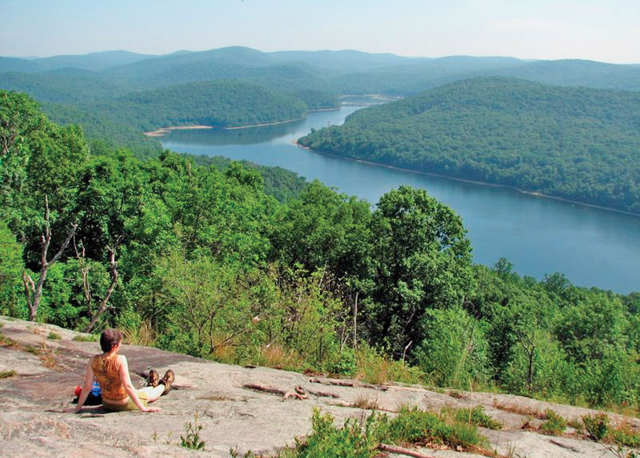
It is hard for any of us to really imagine New Jersey 15,000 years ago, but what is now Irvington was then buried under hundreds of feet of glacial ice. As the ice receded present-day contours of the town emerged, such as the Elizabeth River. As a kid, we called that "The Brook" and it's a natural feature that bisects the town from north to south.

The river enters Irvington 140 feet above sea level and gradually descends as it exits the town at Hillside at an elevation of 70 feet. The land east of the Elizabeth River is a gently rolling plain and west of the river is part of the Orange Mountains. The town's little "mountaintop" reaches 220 feet above sea level at Franklin Terrace.

The Lenape (who were later named Delaware Indians by Europeans) were the natives who lived in what is now New Jersey and along the Delaware River in Pennsylvania, the northern shore of Delaware, and the lower Hudson Valley and New York Harbor in New York when Europeans arrived in the sixteenth and seventeenth centuries.

They were the major tribes that lived in our state

The first inhabitants of this Elizabeth River valley were the Awkinges or Hackensacks, who were a subtribe of the Lenni Lenape. I couldn't find any evidence that there was any significant village there, but before Europeans came to the area there was plentiful game and well-stocked streams.

Around 1676, Newark's first settlers spread out towards the "suburbs" and laid out highways. We know that one Lenape trail became Clinton Avenue which ran straight to the Elizabeth River.

The Lenape Trail of today doesn't pass through Irvington or follow a historical American Indian trail exclusively.  Look at a map of the Lenape Trail (which is a component of the Liberty Water Gap Trail). You can see it go through Becker Park with a side trail that goes to to the Walter Kidde Dinosaur Park. The dinosaur tracks there (including the smallest ones ever found) pre-date even the Lenape but it doesn't tell any of our New Jersey natives' story.

The Lenape Trail continues west across the Morristown and Erie Railway tracks and passes under I-280 and continues along Hatfield Swamp and the Essex County Environmental Center before ending at the Patriots’ Path.

The Lenni Lenape people of our area were divided into smaller groups, but all participated in both hunting and gathering as well as cultivation. Deer, elk, bear, fox, raccoon, opossum, muskrat, beaver, squirrel and rabbit were all hunted for food and furs were used for clothing, bone for fashioning tools, toys, and sewing needles. Sinew was used as sewing thread.

Fish leftovers were used as fertilizer. They made maple sugar and had an abundant supply of natural honey. Cultivated garden plots usually contained corn, beans, pumpkins or squash, and tobacco. 

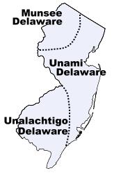
The Minsi  (AKA Munsee) were the "people of the stony country" whose totem was the wolf. They lived in the rugged country along the upper Delaware and their principal village was Minisink, on the east bank at the Delaware Water Gap.

You might know Mount Minsi and Lake Lenape which are located within the Delaware Water Gap National Recreation Area.

They were the largest of the subtribes and most warlike of the Lenape because of their proximity to the fierce Mohawks of the Iroquois nation.

In the Central area of NJ lived the Unami, “the people down the river.”

The southern part of our state was home to the Unilachtigo, “the people who lived near the ocean.”

These were some of the Indians that I read about as a kid in The Last of the Mohicans and the other Leatherstocking Tales of James Fenimore Cooper. I don't think I had any sense that these people had walked over the same lands that I grew up walking over myself.  Many years later, I taught The Light in the Forest in which a European is adopted by a band of Lenape.

The Lenni Lenape people participated in both hunting/gathering as well as cultivation and fishing. In their lands were a great assortment of animals such as deer, elk, bear, fox, raccoon, opossum, muskrat, beaver, squirrel and rabbit. Nothing went to waste. Furs were used for clothing, bone was used for fashioning tools and toys for children as well as being used for sewing needles, and sinew was used as sewing thread.

They spoke what we call an Algonquian language, known as either Lenape or Delaware. Among other Algonquian peoples the Lenape were considered the “grandfathers” from whom all the other Algonquian peoples originated. Consequently, in inter-tribal councils, the Lenape were given the respect one would give to elders.

The Treaty of Easton, signed between the Lenape and the English in 1758, moved them west out of New York and New Jersey and into Pennsylvania. Then they were pushed to Ohio and beyond.

It didn't work to their advantage, but the Lenape were the first Indian tribe ever to enter into a treaty with the United States government. They signed the Treaty of Fort Pitt during the American Revolutionary War and supplied the Continental Army with warriors and scouts in exchange for food supplies.
When the white man arrived, the Lenape had developed an extensive system of trails through the wilderness. These trails were originally 18 inches wide and could only accommodate persons walking in single file. Warriors, messengers, hunters, diplomats and visiting families apparently used separate paths. These Indian paths became bridle trails, wagon roads and twentieth century highways.      via  newhopepa.com
The Lenni-Lenape of New Jersey were peaceful and they were sometimes intermediaries in resolving problems within the nation. The hostile Iroquois mockingly called them “The Old Women.”

North of my hometown of Irvington, the Lenape were also living in what is now the Passaic valley around where I worked for a number of years at Passaic County Community College.

At the Paterson Museum, I learned that the Lenni Lenape Indians knew the Great Falls as a prime camping and fishing site. They called it “Totowa” which meant "to be forced beneath the waters" which shows their respect for the power of the falls.

The Passaic Falls, more popularly known as the Great Falls. There is no record of who first "discovered" the Great Falls. History books record the white settlers who moved into the area following the settlement of Newark in 1666. Of course, the Lenape discovered the Falls long before any white hunters or land prospectors from that colony wandered up the river.

Acquackanonck was the land in lower Passaic County from Essex County line to Pompton. The name is said to be derived from several  Indian words meaning place of brush net + rapid stream. The V-shaped brush nets were set in the river in shallow places so that fish became entangled in the twigs during the seasons when spawning runs of shad and sturgeon were underway.

Over a long period of time, the area of the falls was a productive source of fish for the Indians and later for the white settlers. During the spawning season, shad and other anadromous species (fish that migrate up rivers from the sea to spawn) would come in great numbers to the waters below the falls, where their upstream progress would be stopped.

These large catches couldn't be consumed immediately and much of the catch was dried for later use. Sturgeon, as well as shad, made their way to the foot of the falls and, because of their size, were especially prized. One of the largest ever reported was taken on August 31, 1817, and was said to have weighed 130 pounds.

The Lenape were not the only Indian tribe in this area, but they were the dominant tribe. There is still a group of the Ramapough Lenape Indian Nation (AKA Ramapo Mountain Indians) numbering about 5,000 who live around the Ramapo Mountains of northern New Jersey and southern New York.


Sources

Thursday, April 24, 2014

Hackensack’s Borg’s Woods and Wawayanda Swamp Natural Area

The improving weather makes many of us more enthusiastic about getting out for a walk or hike. Looking through the many options at NJ Urban Forest, I came upon two North Jersey possibilities for this weekend.

Both of these rambles go through areas that were once commercially owned and that were obtained for preservation and recreation.


First up is Hackensack’s Borg’s Woods. About 14 acres of Borg’s Woods were originally owned by Macromedia, Inc., which planned to build a condominium development in the mid-1980s. After years of legal battles, Bergen County purchased the parcel in 1994, and an additional acre of the Summit Hill Ridge was purchased from two homeowners by the County in 1995.

Of course, these urban forests - as the name suggests - have pretty mild and shorter "hikes" that serious hikers would consider more of a walk.

The second trek goes through a section of Wawayanda State Park. The park was one of the first major acquisitions by the New Jersey Green Acres program in 1963 from the New Jersey Zinc Company.


“Wawayanda” is like many NJ locations of Lenape Indian origin. The word is said to mean "water on the mountain," although in modern parlance, some say it means “way way yonder” since the park is rather remotely located in northwestern Passaic and southeastern Sussex counties.

The hike offered takes you to a rare inland Atlantic White Cedar swamp in the 2,167-acre park. The Wawayanda Swamp Natural Area is the largest natural area in the park.

Tuesday, September 24, 2013

Apshawa Forest Hike This Weekend

FOREST HIKE IN APSHAWA
DATE: Saturday, September 28     Apshawa Trails Day hike
TIME: 10 a.m. - noon.
PLACE: Apshawa Preserve, West Milford, Passaic County.
DETAILS: Hike new trails in the Apshawa Preserve with Ingrid Vandegaer, NJ Conservation Foundation's Highlands Regional Manager.
COST: $5 per adult, children free
REGISTRATION: Advance registration required. To register online, go to

Wednesday, February 27, 2013

Preserving Land To Preserve Rivers

The Passaic River Coalition’s Butler Forest Preserve & Butler Raceway are two preserves which are contiguous (connected).

Combined they have a combined acreage of 14.9 acres.Four of those acres are deciduous wooded wetlands.

The preserve is Butler, NJ and these areas were purchased to prevent the development of townhouses and provide protection for the Pequannock River.

At PequannockRiver.org, we are reminded that the area around that river and the Wanaque River is often called the "Heart of the Highlands."

Average citizens may not consider the importance of the lands surrounding rivers when they think about preserving the river itself.

This particular area provides critical water supplies to millions of New Jersey citizens.

It also serves as a refuge for sensitive wildlife endangered, threatened and thankfully stable including otters, eagles, bears and bobcats.

Though some of this area seems quite rugged, other sections are at the edge of suburban sprawl. It is quite rugged at the headwaters on Hamburg Mountain, but the flood plains of eastern Morris County are much more suburban. The latter area is also one that continues to demand more land and water for growth.

Pequannock River
Want to learn more and explore the area? Check out their site and events calendar for meeting, hikes and information.

Thursday, September 6, 2012

New Jersey's Pearl River and the Paterson Pearl

I wrote recently about the Alonzo F. Bonsal Wildlife Preserve in Montclair. This urban forest is the remnants of wetlands and uplands that surround the Third River. The river is a major tributary of the lower Passaic River watershed.

The source (headwaters) of the Third River are in Rifle Camp Park in Woodland Park. The headwaters were impounded in 1899 to form the Great Notch Reservoir which greatly reduced the river’s flow.

The Third River’s current name was derived from the fact that it lies north of two other Passaic River tributaries - the First and Second Rivers.

At one time, the river was known as Pearl River due to the discovery of the "Queen Pearl," also known as the "Paterson Pearl."

freshwater mussels   via fws.gov
Freshwater pearls are found in a river’s mussel population. The Paterson Pearl was a 93 grain pink pearl and was one of the first freshwater pearls to be discovered in the United States. Other pearls were found in the Third River but none matched the Paterson Pearl.

Although freshwater mussels are most diverse in North America, where there are 281 species and 16 subspecies, they are among the most rapidly declining animal groups on the continent. The Nature Conservancy recognizes 55% of North America's mussel species as extinct or imperiled compared to only 7% of the continent's mammal and bird species.

The Paterson Pearl was discovered in Notch Brook, near Paterson, in 1857 by a carpenter named Jacob Quackenbush. It started a "pearl rush" that almost stripped the streams of Notch Brook of freshwater mussels and led to the discovery of some lesser pearls but worth around $15,000.

The pearl rush flowed over to other streams and rivers in New Jersey and it had a very negative impact on mussel populations. High quality pearls were found the Rock Road Brook, the Godwinville Brook and Cherry Lane Brook. The exploitation of the freshwater mussels in the waters of Passaic county and other counties depleted the mussel population, and within a few years the entire population of mussels were totally decimated. That eliminated the natural pearl industry.

The pearl fever spread to other states, and pearls were discovered in New York, Ohio, Texas, Arkansas, Florida, Connecticut, Mississippi and Wisconsin.

IMAGE: Royal Ontario Museum - the
pearl believed to be the "Paterson Pearl"


The "Paterson Pearl" was purchased by Charles L. Tiffany of Tiffany & Co. New York City, for $1,500, and as it was difficult to find buyers for the pearl in the United States, the company sent it to their Paris House for sale at 12,500 francs (about $2,500). The French dealer sold it to Empress Eugenie de Montijo, the Queen consort of Emperor Napoleon III, and it then became known as the "Queen Pearl" or the "American Queen Pearl" or the "Tiffany Queen Pearl."


Other extraordinary pearls are also sometimes referred to as "Queen Pearls."

Today, the mussels and pearls are long gone from these waters and the name Pearl River has been replaced by Third River as designated by cartographers.

SOURCE:
For more history on the Paterson Pearl and the resulting pearl fever, see internetstones.com

Saturday, February 25, 2012

Endangered or Just In Danger Amphibians and Reptiles

A yellow spotted salamander changing lanes

If the unusually warm weather and crocuses blooming in your garden haven't been harbingers of spring, then note that the amphibian migration has begun across a good part of New Jersey.

With the rain yesterday being just about the right temperature, some eager salamanders and frogs are moving to their breeding pools.

Unfortunately, our "Garden State" is also a highway state and crossing is quite dangerous for those creatures. There are some people out there helping out, but keep a watchful eye when driving on rainy nights if you can.

An article in The New York Times, "Bucket Brigade Gives a Lift So Salamanders Can Live to Mate", describes one group of "salamander people" in Mississippi  are out on these rainy, early spring nights scooping up salamanders to help them cross the road. These "herpers" who search for and aid the amphibians or reptiles do their part to try to protect endangered, threatened and just plain in danger creatures.

Some salamanders can live up to 30 years, so they have been down this road (well, really, across this road) before. But they procreate only once a year.

I have written earlier here about similar projects in New Jersey. Saving other, more lovable species might be easier to get attention, volunteers and funding.

The NJDEP, Division of Fish and Wildlife’s Endangered and Nongame Species Program (ENSP), the Conserve Wildlife Foundation of NJ, and the NJ Audubon Society have been partners on the Amphibian Crossing Survey Project. Since 2002, they have been working to protect early-spring breeding amphibians like the wood frog, spotted salamander, jefferson salamander, and spring peeper during their annual migrations, which often lead them across perilous roadways. Volunteers help monitor sites in northern NJ (resources are limited, so that has been the focus area) particularly Warren, Passaic and Morris County. But they also help to identify additional crossings throughout the state.

A single vehicle can crush dozens of the slow-moving animals as they try to cross the road during migration. For example, some major amphibian road-crossings occur in West Milford in Passaic county. On rainy evenings from late February through March, teams of volunteers will be serving as “Crossing Guards” - slowing traffic, moving amphibians across the road, and collecting data about the migration.

According to the ENSP, amphibians are regarded by many scientists as indicators of a region's health and as the first indicators to harmful environmental changes such as pollutants and higher aquatic temperatures. Basically, if we see problems in the amphibian community, it’s just a matter of time before larger organisms (such as birds, mammals, and humans) will be affected as well.

Amphibian populations are declining worldwide as a result of a number of factors, including water pollution, increased pesticide use, and habitat loss, which is the most significant factor for all of New Jersey's species of conservation concern.

Amphibians depend on both terrestrial and aquatic habitats throughout their life cycles. The loss of forests and wetland habitats, including clearing forests, filling in vernal pools, and development that leads to changes in the water table that dry out critical wetlands, only add to these critters’ plight.

Finally, fragmentation of habitat can also play a critical role in the demise of an amphibian population as they attempt to travel from one area to another. Amphibians become easy prey targets in open habitats (lawns, driveways, roads) and at barriers such as curbs and fences that are often impossible to cross.

A spotted salamander being helped across a road.

The Conserve Wildlife Foundation of New Jersey has assembled a resource package to help teachers educate students about New Jersey's reptiles and amphibians. The package includes the Field Guide to Reptiles and Amphibians of NJ and Calls of NJ Frogs and Toads CD, and a teacher's guide full of activities and lesson plans for grades 5-9. The activities are correlated to the state's Core Curriculum Content Standards.

Resource Package Flyer and Order Form (pdf)

Thursday, January 12, 2012

New Jersey's Newest National Park

Not far from downtown Paterson is is the Great Falls on the Passaic River which recently become America's 397th national park. The National Park designation makes the 35-acre site eligible for federal funds.

The 77-foot waterfall in downtown Paterson is second only to Niagara Falls in terms of water volume east of the Mississippi River.


Alexander Hamilton (lieutenant colonel in the American Revolution, confidant to George Washington, delegate to the Constitutional Convention, and first Secretary of the Treasury) formed in 1792 an investment group called the Society of Useful Manufactures (the “SUM”) whose funds would be used to develop a planned industrial city that was later to be known as Paterson.

Hamilton believed that the United States needed to reduce its dependence on foreign goods and should instead develop its own industries. The industries developed in Paterson were powered by the 77-foot high Great Falls of the Passaic, and a system of water raceways that harnessed the power of the falls. The district originally included dozens of mill buildings and other manufacturing structures associated with the textile industry and later, the firearms, silk, and railroad locomotive manufacturing industries. In the latter half of the 1800’s, silk production became the dominant industry and formed the basis of Paterson’s most prosperous period, earning it the nickname “Silk City.”

 Take a look at the Great Falls from a webcam view via EarthCam and the City of Paterson.

Monday, January 24, 2011

Going Local - Garret Mountain and Mills Reservation

I live in the very urban Essex County and work in the only slightly less urban Passaic County. But I pass natural areas every day on my short drive to work and they are places I visit frequently.

Garret Mountain Reservation is Passaic county's major recreational area. It offers visitors grass fields, several miles of walking/running trails, basketball courts, and picnic areas.

Barbour's Pond is state stocked with fish for anglers. This manmade pond is on the Slippery Rock Brook and was created in 1888. Its normal surface area is 11 acres.

There is an Equestrian Center with horseback riding lessons.

This woodland oasis is a good place to see migrating song birds, including 35 species of Warblers, numerous Vireos, Orioles, Sparrows and Thrushes. Birdwatchers from the Tri-state areas flock to this hotspot for great views of 150+ species per year along the easily accessible trails.

Lambert Castle
Lambert Castle, located on the eastern slope of the mountain, just off Route 19, is a 19th century castle which has been recently renovated and now hosts the Passaic County Museum (open to the public).

The "Castle" was built in 1893 by a wealthy silk manufacturer. (Paterson was known as "Silk City".) Many workers believed Catholina Lambert built it high up on the mountain to watch over his mills below.The Morris Canal once ran at the site of Lambert Castle.

This area is especially rich in labor and industrial history.  You can spend several days with visits to Lambert Castle as well as the nearby Paterson Museum-Thomas Rodgers Building [manufactured steam engines] at 2 Market Street, and the Great Falls and related raceway system which was a source of water power (start at the Visitors' Center at 65 McBride Avenue Extension). The American Labor Museum/Botto House was the 1913 silk strike headquarters and is at 83 Norwood Street in Haledon.

http://friendsofgarretmountain.blogspot.com

Trail Information http://www.nynjtc.org/park/garret-mountain-reservation 


Mills Reservation is a county park located on the First Watchung Mountain, consisting of a 157.15-acre (0.6360 km2) protected wooded area located in Cedar Grove and Montclair, New Jersey, United States. The reservation is maintained by the Essex County Park Commission.

In 1954 the Park Commission received a gift of 118.9 acres from the Davella Mills Foundation. The stipulation for the original gift was that the land be preserved in its natural state. Therefore, the only development undertaken on this land was a small parking area and a system of walking trails that gives the public access to the interior—a minimal design by the Olmsteds in their last association with Essex County. There are no buildings in Mills Reservation.

The reservation has several walking/jogging trails, including four major trails and numerous smaller trails. One of the four main trails leads to a cliff that overlooks the New York City skyline. See http://www.nynjtc.org/hike/mills-reservation-new-york-city-view

Activities in Mills Reservation include walking, jogging, hiking, and birding. Bike riding is prohibited by the county - but I have passed a number of cyclists and there is ample evidence of bikes on the trails.

During World War Two, an anti-aircraft gun emplacement was made in Mills Reservation at the southern lookout point (called Quarry Point) on the cliffs overlooking New York City. All that remains of this today is a circular cement platform.

The area has attracted bird watchers who observe migratory birds, such as warblers in the spring and hawks in the fall. The Montclair Hawk Lookout is atop a 500-foot basalt ledge on a ridge across from Quarry Point on the First Watchung Mountain in Montclair, New Jersey. It is a well constructed, stone-filled platform that is the site of the Montclair Hawk Lookout, a sanctuary of the New Jersey Audubon Society.

This is the first ridge west of the lower Hudson River Valley, and runs from northeast to southwest. The view from the platform is south and east with a view of the Verrazano Narrows Bridge, the entire New York City skyline including the Statue of Liberty, all the way northeast to the Palisades. To the north and west, peaks from the Ramapo Mountains can be discerned, and the beginning of the Second Watchung Mountain.

Quarry Point in Mills Reservation is where the Spring Hawk Count is conducted, as the visibility to the south is better from there.

The Montclair Hawk Watch has been conducted there since 1957. It is the second oldest continuous hawk watch in the nation.

Monday, January 17, 2011

Apshawa Preserve


This 576-acre preserve offers a diversity of habitats and beautiful vistas in the heart of the Highlands of northern New Jersey. The 40-acre Butler Reservoir is a scenic attraction for hikers and birdwatchers, and the Apshawa Brook flows through the preserve to the Pequannock River. Apshawa's mixed hardwood forest is dominated by oak and sugar maple.

There are almost seven miles of blazed trails in the Apshawa Preserve open for hiking, bicycling, horseback riding, nature study and fishing.

The Apshawa Preserve is open year round from dawn to dusk for recreation, and can be accessed from Macopin Road in West Milford.


Wednesday, February 24, 2010

Will the Black Bear Hunt Return to NJ in 2010?

Yet another controversy that has come up in NJ news this year is the possibility of a bear hunt again in New Jersey. The state Fish and Game Council may propose New Jersey's first bear hunt since 2005.

Former Gov. Jon Corzine had suspended the last hunt in 2006, but some news reports say that Gov. Chris Christie favors a bear hunt.

A bill was introduced for a new $28 fee on bear hunters that would raise money for the bear management program and it would give the Council sole discretion about a hunt each year.

Corzine had committed to non-lethal bear management.

The Division of Fish and Wildlife saw statistical decreases in complaints about black bear "nuisance" incidents after there were hunts in 2003 and 2005.


Most complaints are about bears getting into garbage, destroying beehives, breaking into homes, destroying livestock and rabbits or attacking dogs.

Complaint calls increased to 900 in 2007 and 1,869 in 2008.


Besides hunting, alternative management includes "averse conditioning," bear-resistant garbage cans and dumpsters, and educating citizens about the Black Bear Feeding Ban Law.

The current population of black bears in NJ is a bit unclear. I found a 2005 population count of at least 1,500 bears. (The area surveyed was a 580-square-mile area of northern New Jersey.) In 1988, when there was a hunt, the population was estimated to be about 150.

Our Jersey Bears are not endangered or threatened. They have an excellent reproductive rate (averaging three cubs to each female) and an extremely strong 70% survival rate.
A number of groups, including the West Milford-based Bear Education and Resource Group, oppose a bear hunt and point to evidence that shows that hunting is an ineffective longterm solution. But other groups, such as New Jersey Hunter, are in favor of the hunt.

Black Bear: North America's Bear

Black Bear: North America's Bear
Black Bears

Tuesday, May 5, 2009

The Passaic River Watershed

The Passaic River runs almost 80 miles (129 km) through northern New Jersey.

It starts by winding its way around the swamp lowlands in and around the Great Swamp taking in through tributaries much of the surface waters of northern portion of the state. In its lower portion, it moves through some of the most urbanized and industrialized areas of the state.

The Passaic River formed as a result of drainage from the massive proglacial lake that formed in Northern New Jersey at the end of the last ice age, approximately 13,000 years ago. Glacial Lake Passaic, as we call it now, had its center in the present lowland swamps of Morris County.


The lake rose as the river was blocked, but eventually broke through at the Millington Gorge and the Paterson Falls as the glacier retreated.

Much of the lower river suffered severe pollution during the nineteenth and twentieth centuries because of the development that grew on its banks - in many cases in order to use the river as a resource or as a garbage dump.

The river's health has improved in the past 30 years. Some of that comes from the enactment of the 1972 Clean Water Act and other environmental legislation. Some improvement has come as a result of the decline of industry along the river.

The water quality is still poor. Sediment at the mouth of the river near Newark Bay still registers contamination by pollutants such as dioxin. Dioxin was produced at the Diamond Shamrock Chemical Plant in Newark as a waste product resulting from the production of the agent orange defoliation chemical used during the Vietnam War. The issue of responsibility for the cleanup of the dioxin contamination has been in the courts for decades without resolution.

The Passaic River flows close to my hometown, but even closer is the Peckman River which is one of the many small tributaries. The Peckman River originates in West Orange and flows northeasterly through Verona, Cedar Grove and Little Falls to its confluence with the Passaic River in the borough of Woodland Park (formerly West Paterson).

The New Jersey Department of Environmental Protection (NJDEP) has issued notices banning commercial fishing and advising the general public that fish caught in the tidal Passaic River (from Dunedee Dam to the mouth at Newark Bay) should not be eaten. Still, I see people fishing along the banks - particularly for catfish.

You can access the the Passaic from a number of county parks. It is pretty much free of industrialization until it reaches the Summit/Chatham border. The upper portion before Summit is far more natural in appearance. I have seen canoeists and kayakers there.

When it enters Essex County, there are some natural marsh lands and wooded areas that make it more inaccessible and somewhat protected.

The more heavily populated areas of Passaic County come next with the lower portions of the river south of Paterson being much wider but more industrialized as it flows into Newark Bay.

The Passaic River is known for chronic flooding problems during heavy rainfall or snow-melt. The worst area is where the Pompton River joins the Passaic River in Wayne, New Jersey.

Unfortunately, building has long been allowed in this flood plain. A plan has been proposed for years to build a 20 mile river flood tunnel. The tunnel would divert flood waters directly into the bay. Some riverside residents have already taken buy-outs from the federal government but many people still live within the flood plain.

The Passaic River Coalition (PRC) gives valuable assistance and stewardship for the preservation and protection of over 1,000 miles of waterways including the Passaic River. It was established in 1969.

Their goals include improvements in land-water resource management, and public health issues by working as an advisor to citizens, other environmental organizations, governments, and businesses. They gather scientific data to be used for creating wise management policies. They create maps and graphic displays that illustrate the physical, demographic, and socioeconomic characteristics of the River and its watershed for reports, open space plans, and natural resource inventories.

Their scope goes beyond the Passaic River's banks and into the larger watershed. They have met a Land Trust goal of obtaining 1000 acres by acquiring 34 properties in 6 counties (Passaic, Morris, Bergen, Essex, Sussex, and Somerset).

Protecting the watershed means protecting drinking water, preserving sensitive wildlife habitat, improving water quality, creating new open space, and promoting natural flood control management.

The PRC has been involved in the creation of new surface supply systems such as the Monksville Reservoir and the development of three Water Supply Master Plans for New Jersey. PRC has assisted in plans to restore Greenwood Lake, a primary water source for northern New Jersey and is creating the overall restoration guide for the Lake.

The next challenge is to address the 46 million gallon per day groundwater deficit in the NJ Highlands. You can join the PRC and donate to their fight.


A Great Conveniency - A Maritime History of the Passaic River,
Hackensack River, and Newark Bay


MORE INFORMATION

Sunday, April 19, 2009

Paterson's Great Falls Named National Historical Park


President Obama recently signed into law the Paterson Great Falls National Historical Park Act. The Paterson Act is part of an omnibus parks and historic preservation bill.

Hamilton statue at the Great Falls
photo via Flickr by Ken Ronkowitz

As the nation’s first Secretary of the Treasury, Alexander Hamilton founded the City of Paterson to begin implementing his plan to harness the force of the Great Falls—then the nation’s largest waterfall—to power new industries that would secure America’s economic independence.

Considering that one federal agency has ranked Paterson as the most economically distressed city in the United States, the local community leaders hope the creation of the national historical park, along with preservation and redevelopment of the historic center of the city, will have a positive impact on Paterson’s 175,000 residents.

Groups such as NJ Heritage Development Coalition are recommending that the state enact a state historic preservation tax credit that will jump start redevelopment in Paterson and across the state.

President Barack Obama’s Remarks
"As Americans, we possess few blessings greater than the vast and varied landscapes that stretch the breadth of our continent. Our lands have always provided great bounty – food and shelter for the first Americans, for settlers and pioneers; the raw materials that grew our industry; the energy that powers our economy.

What these gifts require in return is our wise and responsible stewardship. As our greatest conservationist President, Teddy Roosevelt, put it almost a century ago, “I recognize the right and duty of this generation to develop and use the natural resources of our land; but I do not recognize the right to waste them, or to rob, by wasteful use, the generations that come after us.”

That’s the spirit behind the bipartisan legislation I’m signing today – legislation among the most important in decades to protect, preserve and pass down our nation’s most treasured landscapes to future generations."